Lisse geodata
Lisse (South Holland) is a populated place; located in Netherlands in Europe/Amsterdam (GMT+2) time zone. With population of 22,321 people, there are 155 cities with bigger population in this country. Compared to other cities in Netherlands, 64.9% of cities are located further ↓South; 87.5% of cities are located further →East and 74.9% of cities have higher elevation than Lisse. Note1


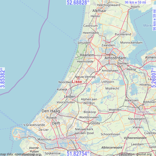
Lisse GPS coordinates[2]
52° 15' 36" North, 4° 33' 24.984" East
| Map corner | latitude | longitude |
|---|---|---|
| Upper-left | 52.68828°, | 3.85382° |
| Center: | 52.26°, | 4.55694° |
| Lower-right: | 51.82754°, | 5.26007° |
| Map W x H: | 95.7×95.7 km | = 59.5×59.5mi |
| max Lat: | 53.48025° ⇑35.1% North |
| Lisse: | 52.26° |
| min Lat: | ⇓64.9% South 50.76917° |
| min Long | Lisse | max Long |
| 3.38611° | 4.55694° | 7.16528° |
| W 12.5%⇐ | ⇒87.5% E |
Elevation
Elevation of Lisse is 2 m = 7 ft, and this is 13 m = 43 ft below average elevation for this country.
| Max E: |
203 m = 666 ft | 74.9% |
| Avg. | 15 m = 49 ft | |
| Lisse | 2 m = 7 ft | |
Min E: |
-6 m = -20 ft | 25.1% |
See also: Netherlands elevation on elevation.city.
Geographical zone
Lisse is located in North temperate zone (between Tropic of Cancer and the Arctic Circle). Distance of this North polar circle is 1590.4 km =988.2 mi to North.| Distance of | km | miles | from Lisse |
|---|---|---|---|
| North Pole | 4196.3 | 2607.5 | to North |
| Arctic Circle | 1590.4 | 988.2 | to North |
| Tropic Cancer | 3204.8 | 1991.4 | to South |
| Equator | 5810.8 | 3610.7 | to South |


Nearby cities:
15 places around Lisse: (largest is in red/bold)
• Abbenes
3.6 km =2.2 mi,  139°
139°
• Beinsdorp
4 km =2.5 mi,  41°
41°
• Bennebroek
7.3 km =4.5 mi,  22°
22°
• De Engel
2.4 km =1.5 mi,  212°
212°
• Hillegom
3.9 km =2.4 mi,  27°
27°
• Lisserbroek
1.1 km =0.7 mi,  109°
109°
• Nieuwe Wetering
7.2 km =4.5 mi, 144°
• Noordwijkerhout
4.4 km =2.7 mi,  272°
272°
• Oude Wetering
7.8 km =4.8 mi,  130°
130°
• Rijpwetering
7.7 km =4.8 mi,  166°
166°
• Sassenheim
4.6 km =2.9 mi, 211°
• Vogelenzang
6.7 km =4.2 mi,  12°
12°
• Voorhout
6.5 km =4 mi,  229°
229°
• Weerestein
5.3 km =3.3 mi, 23°
• Zwaanshoek
7.1 km =4.4 mi, 34°
Sources, notices
• [Note1] Compared only with cities in Netherlands existing in our database
• [Src1] Map data: © OpenStreetMap contributors (CC-BY-SA)
• [Src2] Other city data from geonames.org with taken over terms of usage.
• [Src3] Geographical zone / Annual Mean Temperature by Robert A. Rohde @ Wikipedia
