Oostwoud geodata
Oostwoud (North Holland) is a populated place; located in Netherlands in Europe/Amsterdam (GMT+2) time zone. With population of 875 people, there are 1479 cities with bigger population in this country. Compared to other cities in Netherlands, 77.5% of cities are located further ↓South; 70.7% of cities are located further →East and 98.2% of cities have higher elevation than Oostwoud. Note1


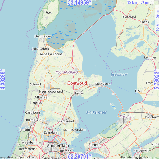
Oostwoud GPS coordinates[2]
52° 43' 32.988" North, 5° 5' 9.996" East
| Map corner | latitude | longitude |
|---|---|---|
| Upper-left | 53.14959°, | 4.38298° |
| Center: | 52.72583°, | 5.08611° |
| Lower-right: | 52.29791°, | 5.78923° |
| Map W x H: | 94.7×94.7 km | = 58.8×58.8mi |
| max Lat: | 53.48025° ⇑22.5% North |
| Oostwoud: | 52.72583° |
| min Lat: | ⇓77.5% South 50.76917° |
| min Long | Oostwoud | max Long |
| 3.38611° | 5.08611° | 7.16528° |
| W 29.3%⇐ | ⇒70.7% E |
Elevation
Elevation of Oostwoud is -2 m = -7 ft, and this is 17 m = 56 ft below average elevation for this country.
| Max E: |
203 m = 666 ft | 98.2% |
| Avg. | 15 m = 49 ft | |
| Oostwoud | -2 m = -7 ft | |
Min E: |
-6 m = -20 ft | 1.8% |
See also: Netherlands elevation on elevation.city.
Geographical zone
Oostwoud is located in North temperate zone (between Tropic of Cancer and the Arctic Circle). Distance of this North polar circle is 1538.6 km =956 mi to North.| Distance of | km | miles | from Oostwoud |
|---|---|---|---|
| North Pole | 4144.5 | 2575.3 | to North |
| Arctic Circle | 1538.6 | 956 | to North |
| Tropic Cancer | 3256.6 | 2023.6 | to South |
| Equator | 5862.6 | 3642.8 | to South |


Nearby cities:
15 places around Oostwoud: (largest is in red/bold)
• Abbekerk
4.6 km =2.9 mi,  278°
278°
• Bangert
6.4 km =4 mi,  80°
80°
• De Weere
6.2 km =3.9 mi,  270°
270°
• Hauwert
2.2 km =1.4 mi,  154°
154°
• Hoorn
9.4 km =5.8 mi,  190°
190°
• Lutjebroek
8.6 km =5.3 mi,  111°
111°
• Medemblik
5.3 km =3.3 mi,  14°
14°
• Midwoud
1.3 km =0.8 mi,  216°
216°
• Onderdijk
4 km =2.5 mi,  60°
60°
• Oosterblokker
6.7 km =4.2 mi,  161°
161°
• Opperdoes
3.8 km =2.4 mi,  348°
348°
• Twisk
2.8 km =1.7 mi,  306°
306°
• Westwoud
5.6 km =3.5 mi,  144°
144°
• Zwaagdijk-Oost
4.2 km =2.6 mi,  119°
119°
• Zwaagdijk-West
6 km =3.7 mi,  200°
200°
Sources, notices
• [Note1] Compared only with cities in Netherlands existing in our database
• [Src1] Map data: © OpenStreetMap contributors (CC-BY-SA)
• [Src2] Other city data from geonames.org with taken over terms of usage.
• [Src3] Geographical zone / Annual Mean Temperature by Robert A. Rohde @ Wikipedia
