Abbekerk geodata
Abbekerk (North Holland) is a populated place; located in Netherlands in Europe/Amsterdam (GMT+2) time zone. With population of 2,110 people, there are 931 cities with bigger population in this country. Compared to other cities in Netherlands, 77.7% of cities are located further ↓South; 72.9% of cities are located further →East and 83.9% of cities have higher elevation than Abbekerk. Note1


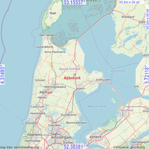
Abbekerk GPS coordinates[2]
52° 43' 54.012" North, 5° 1' 5.016" East
| Map corner | latitude | longitude |
|---|---|---|
| Upper-left | 53.15537°, | 4.31493° |
| Center: | 52.73167°, | 5.01806° |
| Lower-right: | 52.30381°, | 5.72118° |
| Map W x H: | 94.7×94.7 km | = 58.8×58.8mi |
| max Lat: | 53.48025° ⇑22.3% North |
| Abbekerk: | 52.73167° |
| min Lat: | ⇓77.7% South 50.76917° |
| min Long | Abbekerk | max Long |
| 3.38611° | 5.01806° | 7.16528° |
| W 27.1%⇐ | ⇒72.9% E |
Elevation
Elevation of Abbekerk is 1 m = 3 ft, and this is 14 m = 46 ft below average elevation for this country.
| Max E: |
203 m = 666 ft | 83.9% |
| Avg. | 15 m = 49 ft | |
| Abbekerk | 1 m = 3 ft | |
Min E: |
-6 m = -20 ft | 16.1% |
See also: Netherlands elevation on elevation.city.
Geographical zone
Abbekerk is located in North temperate zone (between Tropic of Cancer and the Arctic Circle). Distance of this North polar circle is 1538 km =955.7 mi to North.| Distance of | km | miles | from Abbekerk |
|---|---|---|---|
| North Pole | 4143.8 | 2574.8 | to North |
| Arctic Circle | 1538 | 955.7 | to North |
| Tropic Cancer | 3257.3 | 2024 | to South |
| Equator | 5863.2 | 3643.2 | to South |


Nearby cities:
15 places around Abbekerk: (largest is in red/bold)
• De Weere
1.7 km =1.1 mi,  250°
250°
• Hauwert
6.1 km =3.8 mi,  115°
115°
• Hoogwoud
5.6 km =3.5 mi, 251°
• Medemblik
7.4 km =4.6 mi,  52°
52°
• Middenmeer
8.4 km =5.2 mi,  351°
351°
• Midwoud
4.2 km =2.6 mi,  113°
113°
• Nieuwe-Niedorp
8.1 km =5 mi,  276°
276°
• Onderdijk
8.1 km =5 mi,  80°
80°
• Oostwoud
4.6 km =2.9 mi,  98°
98°
• Opmeer
5.7 km =3.5 mi,  240°
240°
• Opperdoes
4.9 km =3 mi, 51°
• Twisk
2.5 km =1.6 mi,  66°
66°
• Winkel
8.2 km =5.1 mi,  287°
287°
• Zwaagdijk-Oost
8.7 km =5.4 mi, 108°
• Zwaagdijk-West
6.8 km =4.2 mi,  158°
158°
Sources, notices
• [Note1] Compared only with cities in Netherlands existing in our database
• [Src1] Map data: © OpenStreetMap contributors (CC-BY-SA)
• [Src2] Other city data from geonames.org with taken over terms of usage.
• [Src3] Geographical zone / Annual Mean Temperature by Robert A. Rohde @ Wikipedia
