Oosterstreek geodata
Oosterstreek (Friesland) is a populated place; located in Netherlands in Europe/Amsterdam (GMT+2) time zone. With population of 555 people, there are 1772 cities with bigger population in this country. Compared to other cities in Netherlands, 82.6% of cities are located further ↓South; 82.1% of cities are located further ←West and 58.8% of cities have higher elevation than Oosterstreek. Note1


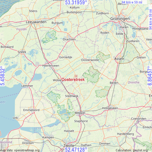
Oosterstreek GPS coordinates[2]
52° 53' 51.036" North, 6° 9' 41.184" East
| Map corner | latitude | longitude |
|---|---|---|
| Upper-left | 53.31959°, | 5.45832° |
| Center: | 52.89751°, | 6.16144° |
| Lower-right: | 52.47128°, | 6.86457° |
| Map W x H: | 94.3×94.3 km | = 58.6×58.6mi |
| max Lat: | 53.48025° ⇑17.4% North |
| Oosterstreek: | 52.89751° |
| min Lat: | ⇓82.6% South 50.76917° |
| min Long | Oosterstreek | max Long |
| 3.38611° | 6.16144° | 7.16528° |
| W 82.1%⇐ | ⇒17.9% E |
Elevation
Elevation of Oosterstreek is 4 m = 13 ft, and this is 11 m = 36 ft below average elevation for this country.
| Max E: |
203 m = 666 ft | 58.8% |
| Avg. | 15 m = 49 ft | |
| Oosterstreek | 4 m = 13 ft | |
Min E: |
-6 m = -20 ft | 41.2% |
See also: Netherlands elevation on elevation.city.
Geographical zone
Oosterstreek is located in North temperate zone (between Tropic of Cancer and the Arctic Circle). Distance of this North polar circle is 1519.5 km =944.2 mi to North.| Distance of | km | miles | from Oosterstreek |
|---|---|---|---|
| North Pole | 4125.4 | 2563.4 | to North |
| Arctic Circle | 1519.5 | 944.2 | to North |
| Tropic Cancer | 3275.7 | 2035.4 | to South |
| Equator | 5881.7 | 3654.7 | to South |


Nearby cities:
15 places around Oosterstreek: (largest is in red/bold)
• Boijl
2.9 km =1.8 mi,  63°
63°
• De Blesse
10.1 km =6.3 mi,  233°
233°
• Hoornsterzwaag
11.3 km =7 mi,  3°
3°
• Katlijk
11.3 km =7 mi,  298°
298°
• Makkinga
10 km =6.2 mi,  22°
22°
• Nieuwehorne
8.9 km =5.5 mi,  312°
312°
• Noordwolde
1.6 km =1 mi,  236°
236°
• Oldeberkoop
4.9 km =3 mi,  335°
335°
• Oldeholtpade
7.7 km =4.8 mi,  266°
266°
• Oudehorne
8.9 km =5.5 mi,  324°
324°
• Steggerda
7.3 km =4.5 mi, 232°
• Vledder
5.6 km =3.5 mi,  145°
145°
• Wilhelminaoord
4.6 km =2.9 mi,  177°
177°
• Willemsoord
10.6 km =6.6 mi,  220°
220°
• Wolvega
11.3 km =7 mi,  257°
257°
Sources, notices
• [Note1] Compared only with cities in Netherlands existing in our database
• [Src1] Map data: © OpenStreetMap contributors (CC-BY-SA)
• [Src2] Other city data from geonames.org with taken over terms of usage.
• [Src3] Geographical zone / Annual Mean Temperature by Robert A. Rohde @ Wikipedia
