Wolvega geodata
Wolvega (Friesland) is a seat of a second-order administrative division; located in Netherlands in Europe/Amsterdam (GMT+2) time zone. With population of 12,730 people, there are 240 cities with bigger population in this country. Compared to other cities in Netherlands, 81.9% of cities are located further ↓South; 72.6% of cities are located further ←West and 54.1% of cities have higher elevation than Wolvega. Note1


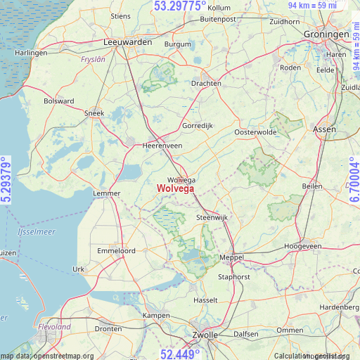
Wolvega GPS coordinates[2]
52° 52' 31.62" North, 5° 59' 48.876" East
| Map corner | latitude | longitude |
|---|---|---|
| Upper-left | 53.29775°, | 5.29379° |
| Center: | 52.87545°, | 5.99691° |
| Lower-right: | 52.449°, | 6.70004° |
| Map W x H: | 94.4×94.4 km | = 58.7×58.7mi |
| max Lat: | 53.48025° ⇑18.1% North |
| Wolvega: | 52.87545° |
| min Lat: | ⇓81.9% South 50.76917° |
| min Long | Wolvega | max Long |
| 3.38611° | 5.99691° | 7.16528° |
| W 72.6%⇐ | ⇒27.4% E |
Elevation
Elevation of Wolvega is 5 m = 16 ft, and this is 10 m = 33 ft below average elevation for this country.
| Max E: |
203 m = 666 ft | 54.1% |
| Avg. | 15 m = 49 ft | |
| Wolvega | 5 m = 16 ft | |
Min E: |
-6 m = -20 ft | 45.9% |
See also: Netherlands elevation on elevation.city.
Geographical zone
Wolvega is located in North temperate zone (between Tropic of Cancer and the Arctic Circle). Distance of this North polar circle is 1522 km =945.7 mi to North.| Distance of | km | miles | from Wolvega |
|---|---|---|---|
| North Pole | 4127.9 | 2565 | to North |
| Arctic Circle | 1522 | 945.7 | to North |
| Tropic Cancer | 3273.3 | 2033.9 | to South |
| Equator | 5879.2 | 3653.2 | to South |


Nearby cities:
15 places around Wolvega: (largest is in red/bold)
• De Blesse
4.7 km =2.9 mi,  140°
140°
• De Greiden
10 km =6.2 mi,  325°
325°
• De Knipe
10.5 km =6.5 mi,  350°
350°
• Katlijk
7.9 km =4.9 mi,  7°
7°
• Mildam
6.7 km =4.2 mi,  2°
2°
• Nieuwehorne
9.5 km =5.9 mi,  27°
27°
• Noordwolde
9.8 km =6.1 mi,  80°
80°
• Oldeholtpade
3.9 km =2.4 mi,  60°
60°
• Oldemarkt
6.2 km =3.9 mi,  193°
193°
• Oranjewoud
8.4 km =5.2 mi,  338°
338°
• Oudeschoot
7 km =4.3 mi, 336°
• Rottum
9.7 km =6 mi,  314°
314°
• Steenwijkerwold
9.1 km =5.7 mi,  150°
150°
• Steggerda
5.6 km =3.5 mi,  110°
110°
• Willemsoord
7 km =4.3 mi, 143°
Sources, notices
• [Note1] Compared only with cities in Netherlands existing in our database
• [Src1] Map data: © OpenStreetMap contributors (CC-BY-SA)
• [Src2] Other city data from geonames.org with taken over terms of usage.
• [Src3] Geographical zone / Annual Mean Temperature by Robert A. Rohde @ Wikipedia
