Hardenberg geodata
Hardenberg (Overijssel) is a populated place; located in Netherlands in Europe/Amsterdam (GMT+2) time zone. With population of 57,909 people, there are 55 cities with bigger population in this country. Compared to other cities in Netherlands, 73.4% of cities are located further ↓South; 91.7% of cities are located further ←West and 62% of cities have lower elevation than Hardenberg. Note1


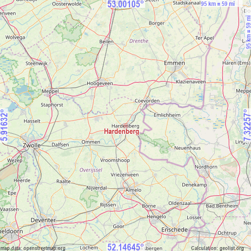
Hardenberg GPS coordinates[2]
52° 34' 32.988" North, 6° 37' 9.984" East
| Map corner | latitude | longitude |
|---|---|---|
| Upper-left | 53.00105°, | 5.91632° |
| Center: | 52.57583°, | 6.61944° |
| Lower-right: | 52.14645°, | 7.32257° |
| Map W x H: | 95×95 km | = 59×59mi |
| max Lat: | 53.48025° ⇑26.6% North |
| Hardenberg: | 52.57583° |
| min Lat: | ⇓73.4% South 50.76917° |
| min Long | Hardenberg | max Long |
| 3.38611° | 6.61944° | 7.16528° |
| W 91.7%⇐ | ⇒8.3% E |
Elevation
Elevation of Hardenberg is 11 m = 36 ft, and this is 4 m = 13 ft below average elevation for this country.
| Max E: |
203 m = 666 ft | 38% |
| Avg. | 15 m = 49 ft | |
| Hardenberg | 11 m = 36 ft | |
Min E: |
-6 m = -20 ft | 62% |
See also: Hardenberg elevation on elevation.city.
Geographical zone
Hardenberg is located in North temperate zone (between Tropic of Cancer and the Arctic Circle). Distance of this North polar circle is 1555.3 km =966.4 mi to North.| Distance of | km | miles | from Hardenberg |
|---|---|---|---|
| North Pole | 4161.2 | 2585.6 | to North |
| Arctic Circle | 1555.3 | 966.4 | to North |
| Tropic Cancer | 3240 | 2013.2 | to South |
| Equator | 5845.9 | 3632.5 | to South |


Nearby cities:
15 places around Hardenberg: (largest is in red/bold)
• Alteveer
14.2 km =8.8 mi,  320°
320°
• Baalder
2.5 km =1.6 mi,  63°
63°
• Ballast
13.2 km =8.2 mi,  35°
35°
• Coevorden
12.5 km =7.8 mi, 40°
• Dalerpeel
11.9 km =7.4 mi,  13°
13°
• De Loo
13.4 km =8.3 mi, 37°
• Kerkenveld
13.1 km =8.1 mi, 321°
• Magele
13.6 km =8.5 mi,  209°
209°
• Nieuw Moscou
12.1 km =7.5 mi,  332°
332°
• Nieuwoord
13 km =8.1 mi,  201°
201°
• Radewijk
6.1 km =3.8 mi,  94°
94°
• Rheezerveen
6.5 km =4 mi,  260°
260°
• Steenwijksmoer
11.7 km =7.3 mi,  27°
27°
• Vroomshoop
13.3 km =8.3 mi, 195°
• Westerhaar-Vriezenveensewijk
13.3 km =8.3 mi,  178°
178°
Sources, notices
• [Note1] Compared only with cities in Netherlands existing in our database
• [Src1] Map data: © OpenStreetMap contributors (CC-BY-SA)
• [Src2] Other city data from geonames.org with taken over terms of usage.
• [Src3] Geographical zone / Annual Mean Temperature by Robert A. Rohde @ Wikipedia
