Dorst geodata
Dorst (North Brabant) is a populated place; located in Netherlands in Europe/Amsterdam (GMT+2) time zone. With population of 1,965 people, there are 970 cities with bigger population in this country. Compared to other cities in Netherlands, 74.4% of cities are located further ↑North; 77.7% of cities are located further →East and 55.1% of cities have lower elevation than Dorst. Note1


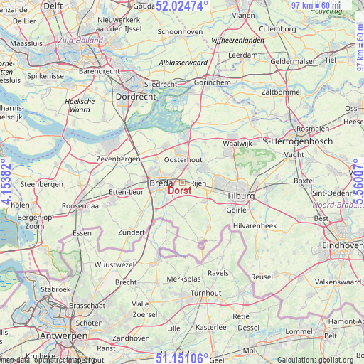
Dorst GPS coordinates[2]
51° 35' 24" North, 4° 51' 24.984" East
| Map corner | latitude | longitude |
|---|---|---|
| Upper-left | 52.02474°, | 4.15382° |
| Center: | 51.59°, | 4.85694° |
| Lower-right: | 51.15106°, | 5.56007° |
| Map W x H: | 97.1×97.1 km | = 60.3×60.3mi |
| max Lat: | 53.48025° ⇑74.4% North |
| Dorst: | 51.59° |
| min Lat: | ⇓25.6% South 50.76917° |
| min Long | Dorst | max Long |
| 3.38611° | 4.85694° | 7.16528° |
| W 22.3%⇐ | ⇒77.7% E |
Elevation
Elevation of Dorst is 8 m = 26 ft, and this is 7 m = 23 ft below average elevation for this country.
| Max E: |
203 m = 666 ft | 44.9% |
| Avg. | 15 m = 49 ft | |
| Dorst | 8 m = 26 ft | |
Min E: |
-6 m = -20 ft | 55.1% |
See also: Netherlands elevation on elevation.city.
Geographical zone
Dorst is located in North temperate zone (between Tropic of Cancer and the Arctic Circle). Distance of this North polar circle is 1664.9 km =1034.5 mi to North.| Distance of | km | miles | from Dorst |
|---|---|---|---|
| North Pole | 4270.8 | 2653.8 | to North |
| Arctic Circle | 1664.9 | 1034.5 | to North |
| Tropic Cancer | 3130.4 | 1945.1 | to South |
| Equator | 5736.3 | 3564.4 | to South |


Nearby cities:
15 places around Dorst: (largest is in red/bold)
• Bavel
3.2 km =2 mi,  214°
214°
• Belcrum
6.1 km =3.8 mi,  279°
279°
• Biesdonk
5.3 km =3.3 mi,  289°
289°
• Breda
5.6 km =3.5 mi,  266°
266°
• Ginneken
5.2 km =3.2 mi,  238°
238°
• Heusdenhout
2.6 km =1.6 mi, 265°
• Hoge Vucht
4.9 km =3 mi, 293°
• Molenschot
2.6 km =1.6 mi,  138°
138°
• Oosterhout
6.1 km =3.8 mi,  1°
1°
• Rijen
4.3 km =2.7 mi,  88°
88°
• Teteringen
3.3 km =2.1 mi,  310°
310°
• Ulvenhout
6 km =3.7 mi,  221°
221°
• Waterdonken
4.2 km =2.6 mi,  301°
301°
• Wisselaar
5.6 km =3.5 mi, 296°
• Zandberg
5.3 km =3.3 mi,  249°
249°
Sources, notices
• [Note1] Compared only with cities in Netherlands existing in our database
• [Src1] Map data: © OpenStreetMap contributors (CC-BY-SA)
• [Src2] Other city data from geonames.org with taken over terms of usage.
• [Src3] Geographical zone / Annual Mean Temperature by Robert A. Rohde @ Wikipedia
