Arnhem geodata
Arnhem (Gelderland) is a seat of a first-order administrative division; located in Netherlands in Europe/Amsterdam (GMT+2) time zone. With population of 141,674 people, there are 12 cities with bigger population in this country. Compared to other cities in Netherlands, 52.5% of cities are located further ↑North; 65.2% of cities are located further ←West and 72.5% of cities have lower elevation than Arnhem. Note1


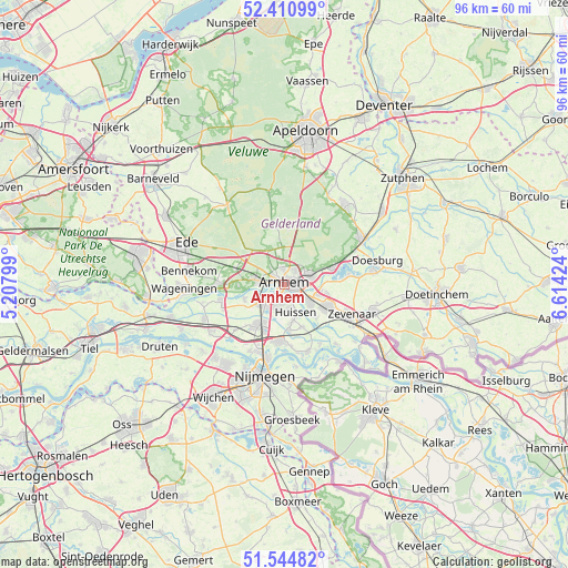
Arnhem GPS coordinates[2]
51° 58' 48" North, 5° 54' 39.996" East
| Map corner | latitude | longitude |
|---|---|---|
| Upper-left | 52.41099°, | 5.20799° |
| Center: | 51.98°, | 5.91111° |
| Lower-right: | 51.54482°, | 6.61424° |
| Map W x H: | 96.3×96.3 km | = 59.8×59.8mi |
| max Lat: | 53.48025° ⇑52.5% North |
| Arnhem: | 51.98° |
| min Lat: | ⇓47.5% South 50.76917° |
| min Long | Arnhem | max Long |
| 3.38611° | 5.91111° | 7.16528° |
| W 65.2%⇐ | ⇒34.8% E |
Elevation
Elevation of Arnhem is 16 m = 52 ft, and this is 1 m = 3 ft above average elevation for this country.
| Max E: |
203 m = 666 ft | 27.5% |
| Arnhem | 16 m 52 ft | |
| Avg. | 15 m = 49 ft | |
Min E: |
-6 m = -20 ft | 72.5% |
See also: Arnhem elevation on elevation.city.
Geographical zone
Arnhem is located in North temperate zone (between Tropic of Cancer and the Arctic Circle). Distance of this North polar circle is 1621.5 km =1007.6 mi to North.| Distance of | km | miles | from Arnhem |
|---|---|---|---|
| North Pole | 4227.4 | 2626.8 | to North |
| Arctic Circle | 1621.5 | 1007.6 | to North |
| Tropic Cancer | 3173.7 | 1972 | to South |
| Equator | 5779.6 | 3591.3 | to South |


Nearby cities:
15 places around Arnhem: (largest is in red/bold)
• Bakenberg
3.6 km =2.2 mi,  320°
320°
• Burgemeesterswijk
1.5 km =0.9 mi, 315°
• Driel
7.1 km =4.4 mi,  250°
250°
• Elden
3.1 km =1.9 mi,  219°
219°
• Geitenkamp
3.2 km =2 mi,  35°
35°
• Gulden Bodem
2.1 km =1.3 mi, 318°
• Heveadorp
6.8 km =4.2 mi,  265°
265°
• Hoogkamp
2.8 km =1.7 mi,  310°
310°
• Malburgen West
1.6 km =1 mi, 215°
• Oosterbeek
4.5 km =2.8 mi,  278°
278°
• Rozendaal
4.5 km =2.8 mi,  50°
50°
• Sterrenberg
2.4 km =1.5 mi, 308°
• Velp
4.6 km =2.9 mi,  68°
68°
• Vredenburg
3 km =1.9 mi,  190°
190°
• Westervoort
5 km =3.1 mi,  122°
122°
Sources, notices
• [Note1] Compared only with cities in Netherlands existing in our database
• [Src1] Map data: © OpenStreetMap contributors (CC-BY-SA)
• [Src2] Other city data from geonames.org with taken over terms of usage.
• [Src3] Geographical zone / Annual Mean Temperature by Robert A. Rohde @ Wikipedia
