Kerikeri geodata
Kerikeri (Northland) is a populated place; located in New Zealand in Pacific/Auckland (GMT+12) time zone. With population of 5,654 people, there are 55 cities with bigger population in this country. Compared to other cities in New Zealand, 98.1% of cities are located further ↓South; 60.4% of cities are located further →East and 70% of cities have lower elevation than Kerikeri. Note1


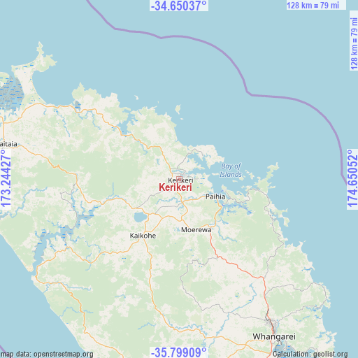
Kerikeri GPS coordinates[2]
35° 13' 36.336" South, 173° 56' 50.604" East
| Map corner | latitude | longitude |
|---|---|---|
| Upper-left | -34.65037°, | 173.24427° |
| Center: | -35.22676°, | 173.94739° |
| Lower-right: | -35.79909°, | 174.65052° |
| Map W x H: | 127.7×127.7 km | = 79.3×79.3mi |
| max Lat: | -34.99604° ⇑1.9% North |
| Kerikeri: | -35.22676° |
| min Lat: | ⇓98.1% South -46.6° |
| min Long | Kerikeri | max Long |
| -176.55973° | 173.94739° | 178.33333° |
| W 39.6%⇐ | ⇒60.4% E |
Elevation
Elevation of Kerikeri is 73 m = 240 ft, and this is 11.4 m = 37 ft below average elevation for this country.
| Max E: |
819 m = 2687 ft | 30% |
| Avg. | 84.4 m = 277 ft | |
| Kerikeri | 73 m = 240 ft | |
Min E: |
3 m = 10 ft | 70% |
See also: New Zealand elevation on elevation.city.
Geographical zone
Kerikeri is located in South temperate zone (between Tropic of Capricorn and the Antarctic Circle). Distance of this Southern Tropic circle is 1310.9 km =814.6 mi to North.| Distance of | km | miles | from Kerikeri |
|---|---|---|---|
| Equator | 3916.8 | 2433.8 | to North |
| Tropic Capricorn | 1310.9 | 814.6 | to North |
| Antarctic Circle | 3484.3 | 2165 | to South |
| South Pole | 6090.2 | 3784.3 | to South |


Nearby cities:
15 places around Kerikeri: (largest is in red/bold)
• Haruru
11.4 km =7.1 mi,  121°
121°
• Kaeo
20.5 km =12.7 mi,  313°
313°
• Kaitaia
63.4 km =39.4 mi,  281°
281°
• Kawakawa
20.5 km =12.7 mi,  148°
148°
• Maungatapere
62.5 km =38.8 mi,  158°
158°
• Moerewa
19.1 km =11.9 mi, 155°
• Ngunguru
66.2 km =41.1 mi,  130°
130°
• Ohaeawai
14.9 km =9.3 mi,  202°
202°
• Okaihau
17.9 km =11.1 mi,  236°
236°
• Paihia
14.4 km =8.9 mi,  114°
114°
• Russell
16.4 km =10.2 mi,  103°
103°
• Taipa
50.7 km =31.5 mi,  300°
300°
• Waimate North
11.6 km =7.2 mi,  210°
210°
• Waitangi
13 km =8.1 mi, 111°
• Whangarei
65.7 km =40.8 mi, 148°
Sources, notices
• [Note1] Compared only with cities in New Zealand existing in our database
• [Src1] Map data: © OpenStreetMap contributors (CC-BY-SA)
• [Src2] Other city data from geonames.org with taken over terms of usage.
• [Src3] Geographical zone / Annual Mean Temperature by Robert A. Rohde @ Wikipedia
