Whangarei geodata
Whangarei (Northland) is a seat of a first-order administrative division; located in New Zealand in Pacific/Auckland (GMT+12) time zone. With population of 50,900 people, there are 17 cities with bigger population in this country. Compared to other cities in New Zealand, 92.8% of cities are located further ↓South; 52.7% of cities are located further →East and 93.7% of cities have higher elevation than Whangarei. Note1


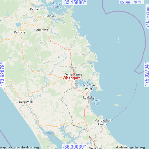
Whangarei GPS coordinates[2]
35° 43' 54.012" South, 174° 19' 26.076" East
| Map corner | latitude | longitude |
|---|---|---|
| Upper-left | -35.15886°, | 173.62079° |
| Center: | -35.73167°, | 174.32391° |
| Lower-right: | -36.30039°, | 175.02704° |
| Map W x H: | 126.9×126.9 km | = 78.9×78.9mi |
| max Lat: | -34.99604° ⇑7.2% North |
| Whangarei: | -35.73167° |
| min Lat: | ⇓92.8% South -46.6° |
| min Long | Whangarei | max Long |
| -176.55973° | 174.32391° | 178.33333° |
| W 47.3%⇐ | ⇒52.7% E |
Elevation
Elevation of Whangarei is 7 m = 23 ft, and this is 77.4 m = 254 ft below average elevation for this country.
| Max E: |
819 m = 2687 ft | 93.7% |
| Avg. | 84.4 m = 277 ft | |
| Whangarei | 7 m = 23 ft | |
Min E: |
3 m = 10 ft | 6.3% |
See also: Whangarei elevation on elevation.city.
Geographical zone
Whangarei is located in South temperate zone (between Tropic of Capricorn and the Antarctic Circle). Distance of this Southern Tropic circle is 1367.1 km =849.5 mi to North.| Distance of | km | miles | from Whangarei |
|---|---|---|---|
| Equator | 3973 | 2468.7 | to North |
| Tropic Capricorn | 1367.1 | 849.5 | to North |
| Antarctic Circle | 3428.2 | 2130.2 | to South |
| South Pole | 6034.1 | 3749.4 | to South |


Nearby cities:
15 places around Whangarei: (largest is in red/bold)
• Dargaville
45.6 km =28.3 mi,  240°
240°
• Haruru
55.8 km =34.7 mi,  334°
334°
• Kaiwaka
49.7 km =30.9 mi,  166°
166°
• Kawakawa
45.2 km =28.1 mi, 329°
• Maungatapere
11.4 km =7.1 mi,  259°
259°
• Maungaturoto
41.1 km =25.5 mi, 174°
• Moerewa
46.8 km =29.1 mi, 325°
• Ngunguru
20.4 km =12.7 mi,  51°
51°
• Ohaeawai
58.2 km =36.2 mi,  316°
316°
• Paihia
54.4 km =33.8 mi,  337°
337°
• Ruakaka
22.7 km =14.1 mi,  149°
149°
• Russell
55.4 km =34.4 mi, 340°
• Waimate North
61 km =37.9 mi, 319°
• Waitangi
55.8 km =34.7 mi, 336°
• Wellsford
63.7 km =39.6 mi,  164°
164°
In other languages:
- In Italian: Distretto di Whangarei
- In Russian: Вангареи, Фангареи
- In Chinese: 旺阿雷
Sources, notices
• [Note1] Compared only with cities in New Zealand existing in our database
• [Src1] Map data: © OpenStreetMap contributors (CC-BY-SA)
• [Src2] Other city data from geonames.org with taken over terms of usage.
• [Src3] Geographical zone / Annual Mean Temperature by Robert A. Rohde @ Wikipedia
