Christchurch geodata
Christchurch (Canterbury) is a seat of a first-order administrative division; located in New Zealand in Pacific/Auckland (GMT+12) time zone. With population of 363,926 people, there are 2 cities with bigger population in this country. Compared to other cities in New Zealand, 78.3% of cities are located further ↑North; 73.9% of cities are located further →East and 72.9% of cities have higher elevation than Christchurch. Note1


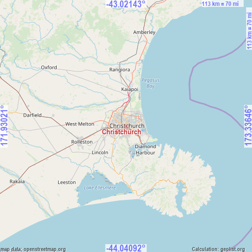
Christchurch GPS coordinates[2]
43° 31' 59.988" South, 172° 37' 59.988" East
| Map corner | latitude | longitude |
|---|---|---|
| Upper-left | -43.02143°, | 171.93021° |
| Center: | -43.53333°, | 172.63333° |
| Lower-right: | -44.04092°, | 173.33646° |
| Map W x H: | 113.4×113.4 km | = 70.5×70.5mi |
| max Lat: | -34.99604° ⇑78.3% North |
| Christchurch: | -43.53333° |
| min Lat: | ⇓21.7% South -46.6° |
| min Long | Christchurch | max Long |
| -176.55973° | 172.63333° | 178.33333° |
| W 26.1%⇐ | ⇒73.9% E |
Elevation
Elevation of Christchurch is 14 m = 46 ft, and this is 70.4 m = 231 ft below average elevation for this country.
| Max E: |
819 m = 2687 ft | 72.9% |
| Avg. | 84.4 m = 277 ft | |
| Christchurch | 14 m = 46 ft | |
Min E: |
3 m = 10 ft | 27.1% |
See also: Christchurch elevation on elevation.city.
Geographical zone
Christchurch is located in South temperate zone (between Tropic of Capricorn and the Antarctic Circle). Distance of this Southern Tropic circle is 2234.5 km =1388.5 mi to North.| Distance of | km | miles | from Christchurch |
|---|---|---|---|
| Equator | 4840.5 | 3007.7 | to North |
| Tropic Capricorn | 2234.5 | 1388.5 | to North |
| Antarctic Circle | 2560.7 | 1591.1 | to South |
| South Pole | 5166.6 | 3210.4 | to South |


Nearby cities:
15 places around Christchurch: (largest is in red/bold)
• Akaroa
40.4 km =25.1 mi,  138°
138°
• Amberley
42.7 km =26.5 mi,  10°
10°
• Burnham
27.1 km =16.8 mi,  250°
250°
• Darfield
42 km =26.1 mi,  277°
277°
• Kaiapoi
17.2 km =10.7 mi,  1°
1°
• Leeston
37.3 km =23.2 mi,  225°
225°
• Lincoln
17.7 km =11 mi,  222°
222°
• Oxford
44.7 km =27.8 mi,  305°
305°
• Prebbleton
10.9 km =6.8 mi,  239°
239°
• Rakaia
55.2 km =34.3 mi, 244°
• Rolleston
20.9 km =13 mi, 254°
• Sefton
31.6 km =19.6 mi, 4°
• Southbridge
44.1 km =27.4 mi, 224°
• Waikuku
26.3 km =16.3 mi, 8°
• Woodend
24.2 km =15 mi, 6°
Sources, notices
• [Note1] Compared only with cities in New Zealand existing in our database
• [Src1] Map data: © OpenStreetMap contributors (CC-BY-SA)
• [Src2] Other city data from geonames.org with taken over terms of usage.
• [Src3] Geographical zone / Annual Mean Temperature by Robert A. Rohde @ Wikipedia
