Kaiapoi geodata
Kaiapoi (Canterbury) is a populated place; located in New Zealand in Pacific/Auckland (GMT+12) time zone. With population of 10,200 people, there are 42 cities with bigger population in this country. Compared to other cities in New Zealand, 77.3% of cities are located further ↑North; 73.4% of cities are located further →East and 99% of cities have higher elevation than Kaiapoi. Note1


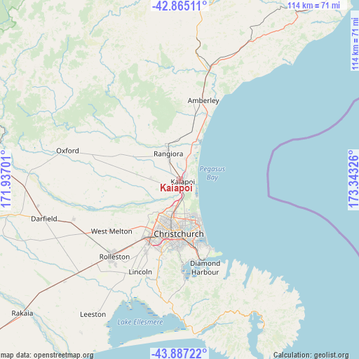
Kaiapoi GPS coordinates[2]
43° 22' 41.952" South, 172° 38' 24.468" East
| Map corner | latitude | longitude |
|---|---|---|
| Upper-left | -42.86511°, | 171.93701° |
| Center: | -43.37832°, | 172.64013° |
| Lower-right: | -43.88722°, | 173.34326° |
| Map W x H: | 113.6×113.6 km | = 70.6×70.6mi |
| max Lat: | -34.99604° ⇑77.3% North |
| Kaiapoi: | -43.37832° |
| min Lat: | ⇓22.7% South -46.6° |
| min Long | Kaiapoi | max Long |
| -176.55973° | 172.64013° | 178.33333° |
| W 26.6%⇐ | ⇒73.4% E |
Elevation
Elevation of Kaiapoi is 4 m = 13 ft, and this is 80.4 m = 264 ft below average elevation for this country.
| Max E: |
819 m = 2687 ft | 99% |
| Avg. | 84.4 m = 277 ft | |
| Kaiapoi | 4 m = 13 ft | |
Min E: |
3 m = 10 ft | 1% |
See also: New Zealand elevation on elevation.city.
Geographical zone
Kaiapoi is located in South temperate zone (between Tropic of Capricorn and the Antarctic Circle). Distance of this Southern Tropic circle is 2217.3 km =1377.8 mi to North.| Distance of | km | miles | from Kaiapoi |
|---|---|---|---|
| Equator | 4823.2 | 2997 | to North |
| Tropic Capricorn | 2217.3 | 1377.8 | to North |
| Antarctic Circle | 2578 | 1601.9 | to South |
| South Pole | 5183.8 | 3221.1 | to South |


Nearby cities:
15 places around Kaiapoi: (largest is in red/bold)
• Akaroa
54.2 km =33.7 mi,  150°
150°
• Amberley
25.8 km =16 mi,  16°
16°
• Burnham
37.2 km =23.1 mi,  224°
224°
• Christchurch
17.2 km =10.7 mi,  181°
181°
• Darfield
43.9 km =27.3 mi,  254°
254°
• Leeston
51.1 km =31.8 mi,  212°
212°
• Lincoln
32.7 km =20.3 mi,  202°
202°
• Oxford
38 km =23.6 mi,  283°
283°
• Prebbleton
24.9 km =15.5 mi, 203°
• Rakaia
65 km =40.4 mi,  230°
230°
• Rolleston
30.8 km =19.1 mi, 222°
• Sefton
14.4 km =8.9 mi,  8°
8°
• Southbridge
58 km =36 mi, 212°
• Waikuku
9.4 km =5.8 mi, 21°
• Woodend
7.2 km =4.5 mi, 17°
Sources, notices
• [Note1] Compared only with cities in New Zealand existing in our database
• [Src1] Map data: © OpenStreetMap contributors (CC-BY-SA)
• [Src2] Other city data from geonames.org with taken over terms of usage.
• [Src3] Geographical zone / Annual Mean Temperature by Robert A. Rohde @ Wikipedia
