Maungaturoto geodata
Maungaturoto (Northland) is a populated place; located in New Zealand in Pacific/Auckland (GMT+12) time zone. With population of 790 people, there are 155 cities with bigger population in this country. Compared to other cities in New Zealand, 90.8% of cities are located further ↓South; 52.2% of cities are located further →East and 56.5% of cities have lower elevation than Maungaturoto. Note1


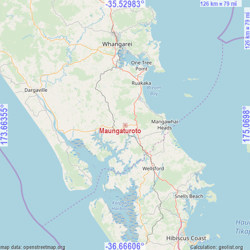
Maungaturoto GPS coordinates[2]
36° 6' 0" South, 174° 22' 0.012" East
| Map corner | latitude | longitude |
|---|---|---|
| Upper-left | -35.52983°, | 173.66355° |
| Center: | -36.1°, | 174.36667° |
| Lower-right: | -36.66606°, | 175.0698° |
| Map W x H: | 126.3×126.3 km | = 78.5×78.5mi |
| max Lat: | -34.99604° ⇑9.2% North |
| Maungaturoto: | -36.1° |
| min Lat: | ⇓90.8% South -46.6° |
| min Long | Maungaturoto | max Long |
| -176.55973° | 174.36667° | 178.33333° |
| W 47.8%⇐ | ⇒52.2% E |
Elevation
Elevation of Maungaturoto is 42 m = 138 ft, and this is 42.4 m = 139 ft below average elevation for this country.
| Max E: |
819 m = 2687 ft | 43.5% |
| Avg. | 84.4 m = 277 ft | |
| Maungaturoto | 42 m = 138 ft | |
Min E: |
3 m = 10 ft | 56.5% |
See also: New Zealand elevation on elevation.city.
Geographical zone
Maungaturoto is located in South temperate zone (between Tropic of Capricorn and the Antarctic Circle). Distance of this Southern Tropic circle is 1408 km =874.9 mi to North.| Distance of | km | miles | from Maungaturoto |
|---|---|---|---|
| Equator | 4013.9 | 2494.1 | to North |
| Tropic Capricorn | 1408 | 874.9 | to North |
| Antarctic Circle | 3387.2 | 2104.7 | to South |
| South Pole | 5993.1 | 3723.9 | to South |


Nearby cities:
15 places around Maungaturoto: (largest is in red/bold)
• Dargaville
47.3 km =29.4 mi,  293°
293°
• Kaiwaka
10.5 km =6.5 mi,  134°
134°
• Kawakawa
84.2 km =52.3 mi,  341°
341°
• Maungatapere
41.7 km =25.9 mi, 338°
• Moerewa
85.2 km =52.9 mi, 339°
• Muriwai Beach
80 km =49.7 mi,  174°
174°
• Murrays Bay
77.8 km =48.3 mi,  153°
153°
• Ngunguru
55.1 km =34.2 mi,  12°
12°
• North Shore
85 km =52.8 mi,  156°
156°
• Parakai
61.4 km =38.2 mi, 174°
• Rothesay Bay
77.2 km =48 mi, 154°
• Ruakaka
22.6 km =14 mi,  19°
19°
• Warkworth
42.9 km =26.7 mi,  141°
141°
• Wellsford
24.4 km =15.2 mi, 146°
• Whangarei
41.1 km =25.5 mi,  354°
354°
Sources, notices
• [Note1] Compared only with cities in New Zealand existing in our database
• [Src1] Map data: © OpenStreetMap contributors (CC-BY-SA)
• [Src2] Other city data from geonames.org with taken over terms of usage.
• [Src3] Geographical zone / Annual Mean Temperature by Robert A. Rohde @ Wikipedia
