Llocllapampa geodata
Llocllapampa (Junin) is a seat of a third-order administrative division; located in Peru in America/Lima (GMT-5) time zone. In our database, there are 305 cities with bigger population. Compared to other cities in Peru, 50.9% of cities are located further ↑North; 51.2% of cities are located further ←West and 79.3% of cities have lower elevation than Llocllapampa. Note1


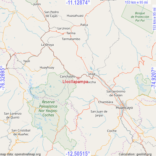
Llocllapampa GPS coordinates[2]
11° 49' 4.116" South, 75° 37' 25.752" West
| Map corner | latitude | longitude |
|---|---|---|
| Upper-left | -11.12874°, | -76.32695° |
| Center: | -11.81781°, | -75.62382° |
| Lower-right: | -12.50515°, | -74.9207° |
| Map W x H: | 153×153 km | = 95.1×95.1mi |
| max Lat: | -0.96667° ⇑50.9% North |
| Llocllapampa: | -11.81781° |
| min Lat: | ⇓49.1% South -18.01465° |
| min Long | Llocllapampa | max Long |
| -81.30472° | -75.62382° | -69.04167° |
| W 51.2%⇐ | ⇒48.8% E |
Elevation
Elevation of Llocllapampa is 3509 m = 11512 ft, and this is 1190.3 m = 3905 ft above average elevation for this country.
| Max E: |
5022 m = 16476 ft | 20.7% |
| Llocllapampa | 3509 m 11512 ft | |
| Avg. | 2318.7 m = 7607 ft | |
Min E: |
1 m = 3 ft | 79.3% |
See also: Peru elevation on elevation.city.
Geographical zone
Llocllapampa is located in South Torrid zone (between Equator and Tropic of Capricorn). Distance of this Southern Tropic circle is 1291.9 km =802.7 mi to South.| Distance of | km | miles | from Llocllapampa |
|---|---|---|---|
| Equator | 1314 | 816.5 | to North |
| Tropic Capricorn | 1291.9 | 802.7 | to South |
| Antarctic Circle | 6087.2 | 3782.4 | to South |
| South Pole | 8693 | 5401.6 | to South |


Nearby cities:
15 places around Llocllapampa: (largest is in red/bold)
• Acolla
12.7 km =7.9 mi,  41°
41°
• Canchayllo
10.2 km =6.3 mi,  277°
277°
• Chacapalpa
17.2 km =10.7 mi,  303°
303°
• Concho
11.8 km =7.3 mi,  29°
29°
• El Rosario
6.6 km =4.1 mi, 303°
• Huaripampa
16.6 km =10.3 mi,  86°
86°
• Huertas
17.2 km =10.7 mi,  71°
71°
• Jauja
14.6 km =9.1 mi, 71°
• Marco
10.8 km =6.7 mi, 37°
• Paca
16.4 km =10.2 mi,  45°
45°
• Paccha
13.3 km =8.3 mi,  107°
107°
• Pancan
16.8 km =10.4 mi,  62°
62°
• Parco
8.7 km =5.4 mi,  76°
76°
• Pomacancha
8.8 km =5.5 mi,  359°
359°
• Sausa
15.4 km =9.6 mi, 79°
Sources, notices
• [Note1] Compared only with cities in Peru existing in our database
• [Src1] Map data: © OpenStreetMap contributors (CC-BY-SA)
• [Src2] Other city data from geonames.org with taken over terms of usage.
• [Src3] Geographical zone / Annual Mean Temperature by Robert A. Rohde @ Wikipedia
