Huanta geodata
Huanta (Ayacucho) is a seat of a third-order administrative division; located in Peru in America/Lima (GMT-5) time zone. With population of 18,627 people, there are 88 cities with bigger population in this country. Compared to other cities in Peru, 60.8% of cities are located further ↑North; 63.9% of cities are located further ←West and 55.7% of cities have higher elevation than Huanta. Note1


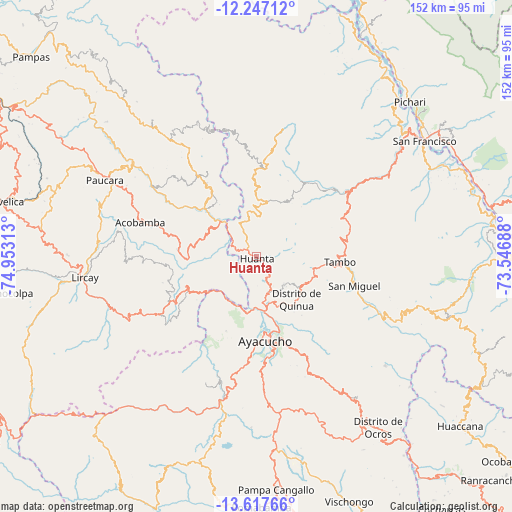
Huanta GPS coordinates[2]
12° 55' 59.988" South, 74° 15' 0" West
| Map corner | latitude | longitude |
|---|---|---|
| Upper-left | -12.24712°, | -74.95313° |
| Center: | -12.93333°, | -74.25° |
| Lower-right: | -13.61766°, | -73.54688° |
| Map W x H: | 152.4×152.4 km | = 94.7×94.7mi |
| max Lat: | -0.96667° ⇑60.8% North |
| Huanta: | -12.93333° |
| min Lat: | ⇓39.2% South -18.01465° |
| min Long | Huanta | max Long |
| -81.30472° | -74.25° | -69.04167° |
| W 63.9%⇐ | ⇒36.1% E |
Elevation
Elevation of Huanta is 2659 m = 8724 ft, and this is 340.3 m = 1116 ft above average elevation for this country.
| Max E: |
5022 m = 16476 ft | 55.7% |
| Huanta | 2659 m 8724 ft | |
| Avg. | 2318.7 m = 7607 ft | |
Min E: |
1 m = 3 ft | 44.3% |
See also: Peru elevation on elevation.city.
Geographical zone
Huanta is located in South Torrid zone (between Equator and Tropic of Capricorn). Distance of this Southern Tropic circle is 1167.9 km =725.7 mi to South.| Distance of | km | miles | from Huanta |
|---|---|---|---|
| Equator | 1438.1 | 893.6 | to North |
| Tropic Capricorn | 1167.9 | 725.7 | to South |
| Antarctic Circle | 5963.1 | 3705.3 | to South |
| South Pole | 8569 | 5324.5 | to South |


Nearby cities:
15 places around Huanta: (largest is in red/bold)
• Antaparco
23.5 km =14.6 mi,  228°
228°
• Ayacucho
25.2 km =15.7 mi,  173°
173°
• Caja
24.1 km =15 mi,  283°
283°
• Carmen Alto
27.8 km =17.3 mi, 174°
• Chincho
13.2 km =8.2 mi,  253°
253°
• Huamanguilla
11.6 km =7.2 mi,  137°
137°
• Julcamarca
22.6 km =14 mi, 247°
• Luricocha
9.4 km =5.8 mi,  348°
348°
• Macachacra
7.8 km =4.8 mi, 135°
• Marcas
15.5 km =9.6 mi,  291°
291°
• Mayocc
23.3 km =14.5 mi,  315°
315°
• Pacaycasa
14.3 km =8.9 mi,  163°
163°
• Quinua
17.7 km =11 mi, 136°
• Tambo
25.3 km =15.7 mi,  90°
90°
• Ticllas
23.9 km =14.9 mi,  202°
202°
Sources, notices
• [Note1] Compared only with cities in Peru existing in our database
• [Src1] Map data: © OpenStreetMap contributors (CC-BY-SA)
• [Src2] Other city data from geonames.org with taken over terms of usage.
• [Src3] Geographical zone / Annual Mean Temperature by Robert A. Rohde @ Wikipedia
