Pacaycasa geodata
Pacaycasa (Ayacucho) is a seat of a third-order administrative division; located in Peru in America/Lima (GMT-5) time zone. In our database, there are 305 cities with bigger population. Compared to other cities in Peru, 61.8% of cities are located further ↑North; 64.4% of cities are located further ←West and 58% of cities have higher elevation than Pacaycasa. Note1


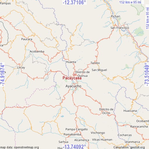
Pacaycasa GPS coordinates[2]
13° 3' 24.984" South, 74° 12' 48.996" West
| Map corner | latitude | longitude |
|---|---|---|
| Upper-left | -12.37106°, | -74.91674° |
| Center: | -13.05694°, | -74.21361° |
| Lower-right: | -13.74092°, | -73.51049° |
| Map W x H: | 152.3×152.3 km | = 94.6×94.6mi |
| max Lat: | -0.96667° ⇑61.8% North |
| Pacaycasa: | -13.05694° |
| min Lat: | ⇓38.2% South -18.01465° |
| min Long | Pacaycasa | max Long |
| -81.30472° | -74.21361° | -69.04167° |
| W 64.4%⇐ | ⇒35.6% E |
Elevation
Elevation of Pacaycasa is 2563 m = 8409 ft, and this is 244.3 m = 802 ft above average elevation for this country.
| Max E: |
5022 m = 16476 ft | 58% |
| Pacaycasa | 2563 m 8409 ft | |
| Avg. | 2318.7 m = 7607 ft | |
Min E: |
1 m = 3 ft | 42% |
See also: Peru elevation on elevation.city.
Geographical zone
Pacaycasa is located in South Torrid zone (between Equator and Tropic of Capricorn). Distance of this Southern Tropic circle is 1154.1 km =717.1 mi to South.| Distance of | km | miles | from Pacaycasa |
|---|---|---|---|
| Equator | 1451.8 | 902.1 | to North |
| Tropic Capricorn | 1154.1 | 717.1 | to South |
| Antarctic Circle | 5949.4 | 3696.8 | to South |
| South Pole | 8555.3 | 5316 | to South |


Nearby cities:
15 places around Pacaycasa: (largest is in red/bold)
• Antaparco
21.6 km =13.4 mi,  265°
265°
• Ayacucho
11.4 km =7.1 mi,  185°
185°
• Carmen Alto
14 km =8.7 mi,  184°
184°
• Chiara
24 km =14.9 mi, 177°
• Chincho
19.4 km =12.1 mi,  301°
301°
• Huamanguilla
6.4 km =4 mi,  37°
37°
• Huanta
14.3 km =8.9 mi,  343°
343°
• Julcamarca
25.2 km =15.7 mi,  281°
281°
• Luricocha
23.7 km =14.7 mi,  345°
345°
• Macachacra
8.3 km =5.2 mi,  10°
10°
• Quinua
8.2 km =5.1 mi,  83°
83°
• Socos
19.4 km =12.1 mi,  204°
204°
• Tambillo
18.7 km =11.6 mi,  143°
143°
• Tambo
25.4 km =15.8 mi,  57°
57°
• Ticllas
15.4 km =9.6 mi,  236°
236°
Sources, notices
• [Note1] Compared only with cities in Peru existing in our database
• [Src1] Map data: © OpenStreetMap contributors (CC-BY-SA)
• [Src2] Other city data from geonames.org with taken over terms of usage.
• [Src3] Geographical zone / Annual Mean Temperature by Robert A. Rohde @ Wikipedia
