Progreso geodata
Progreso (Apurímac) is a seat of a third-order administrative division; located in Peru in America/Lima (GMT-5) time zone. In our database, there are 305 cities with bigger population. Compared to other cities in Peru, 75.2% of cities are located further ↑North; 77.7% of cities are located further ←West and 92.9% of cities have lower elevation than Progreso. Note1


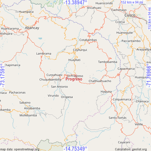
Progreso GPS coordinates[2]
14° 4' 21" South, 72° 28' 22.008" West
| Map corner | latitude | longitude |
|---|---|---|
| Upper-left | -13.38947°, | -73.17591° |
| Center: | -14.0725°, | -72.47278° |
| Lower-right: | -14.75349°, | -71.76966° |
| Map W x H: | 151.7×151.7 km | = 94.3×94.3mi |
| max Lat: | -0.96667° ⇑75.2% North |
| Progreso: | -14.0725° |
| min Lat: | ⇓24.8% South -18.01465° |
| min Long | Progreso | max Long |
| -81.30472° | -72.47278° | -69.04167° |
| W 77.7%⇐ | ⇒22.3% E |
Elevation
Elevation of Progreso is 3932 m = 12900 ft, and this is 1613.3 m = 5293 ft above average elevation for this country.
| Max E: |
5022 m = 16476 ft | 7.1% |
| Progreso | 3932 m 12900 ft | |
| Avg. | 2318.7 m = 7607 ft | |
Min E: |
1 m = 3 ft | 92.9% |
See also: Peru elevation on elevation.city.
Geographical zone
Progreso is located in South Torrid zone (between Equator and Tropic of Capricorn). Distance of this Southern Tropic circle is 1041.2 km =647 mi to South.| Distance of | km | miles | from Progreso |
|---|---|---|---|
| Equator | 1564.7 | 972.3 | to North |
| Tropic Capricorn | 1041.2 | 647 | to South |
| Antarctic Circle | 5836.5 | 3626.6 | to South |
| South Pole | 8442.3 | 5245.8 | to South |


Nearby cities:
15 places around Progreso: (largest is in red/bold)
• Ayrihuanca
15.5 km =9.6 mi,  256°
256°
• Challhuahuacho
24.5 km =15.2 mi,  101°
101°
• Chuquibambilla
25.4 km =15.8 mi, 262°
• Coyllurqui
26.6 km =16.5 mi,  9°
9°
• Curpahuasi
21.3 km =13.2 mi,  273°
273°
• Haquira
34.2 km =21.3 mi,  117°
117°
• Huayllati
16.1 km =10 mi,  355°
355°
• Mamara
21.3 km =13.2 mi,  215°
215°
• Oropesa
22.3 km =13.9 mi,  203°
203°
• Palpacachi
22.8 km =14.2 mi,  351°
351°
• Pataypampa
24.5 km =15.2 mi,  242°
242°
• San Antonio
19 km =11.8 mi, 237°
• Santa Rosa
22.6 km =14 mi,  247°
247°
• Turpay
23.1 km =14.4 mi, 224°
• Vilcabamba
16.5 km =10.3 mi, 268°
Sources, notices
• [Note1] Compared only with cities in Peru existing in our database
• [Src1] Map data: © OpenStreetMap contributors (CC-BY-SA)
• [Src2] Other city data from geonames.org with taken over terms of usage.
• [Src3] Geographical zone / Annual Mean Temperature by Robert A. Rohde @ Wikipedia
