Masma geodata
Masma (Junin) is a seat of a third-order administrative division; located in Peru in America/Lima (GMT-5) time zone. In our database, there are 305 cities with bigger population. Compared to other cities in Peru, 50% of cities are located further ↓South; 53.5% of cities are located further ←West and 78.3% of cities have lower elevation than Masma. Note1


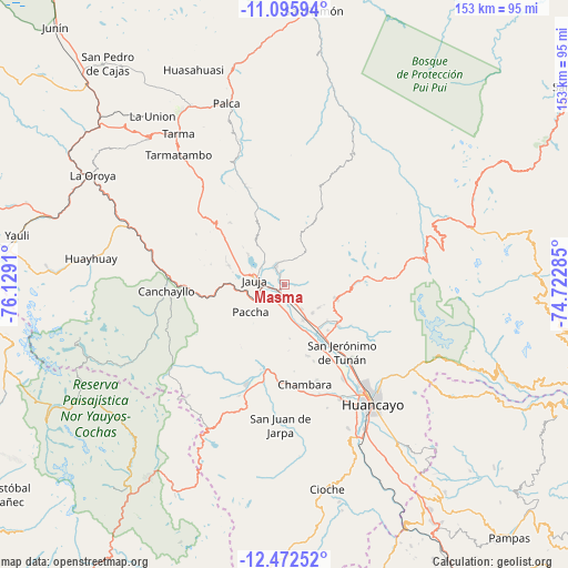
Masma GPS coordinates[2]
11° 47' 6.324" South, 75° 25' 33.492" West
| Map corner | latitude | longitude |
|---|---|---|
| Upper-left | -11.09594°, | -76.1291° |
| Center: | -11.78509°, | -75.42597° |
| Lower-right: | -12.47252°, | -74.72285° |
| Map W x H: | 153.1×153.1 km | = 95.1×95.1mi |
| max Lat: | -0.96667° ⇑50% North |
| Masma: | -11.78509° |
| min Lat: | ⇓50% South -18.01465° |
| min Long | Masma | max Long |
| -81.30472° | -75.42597° | -69.04167° |
| W 53.5%⇐ | ⇒46.5% E |
Elevation
Elevation of Masma is 3488 m = 11444 ft, and this is 1169.3 m = 3836 ft above average elevation for this country.
| Max E: |
5022 m = 16476 ft | 21.7% |
| Masma | 3488 m 11444 ft | |
| Avg. | 2318.7 m = 7607 ft | |
Min E: |
1 m = 3 ft | 78.3% |
See also: Peru elevation on elevation.city.
Geographical zone
Masma is located in South Torrid zone (between Equator and Tropic of Capricorn). Distance of this Southern Tropic circle is 1295.5 km =805 mi to South.| Distance of | km | miles | from Masma |
|---|---|---|---|
| Equator | 1310.4 | 814.2 | to North |
| Tropic Capricorn | 1295.5 | 805 | to South |
| Antarctic Circle | 6090.8 | 3784.6 | to South |
| South Pole | 8696.7 | 5403.9 | to South |


Nearby cities:
15 places around Masma: (largest is in red/bold)
• Apata
11 km =6.8 mi,  134°
134°
• Ataura
2.3 km =1.4 mi,  219°
219°
• Huamali
2.5 km =1.6 mi,  176°
176°
• Huaripampa
5.6 km =3.5 mi,  242°
242°
• Huertas
5.6 km =3.5 mi,  289°
289°
• Jauja
7.8 km =4.8 mi,  277°
277°
• Julcan
3 km =1.9 mi,  338°
338°
• Masma Chicche
5.2 km =3.2 mi,  91°
91°
• Molinos
5.7 km =3.5 mi, 340°
• Muqui
5.5 km =3.4 mi,  189°
189°
• Muquiyauyo
4.5 km =2.8 mi, 224°
• Pancan
7.7 km =4.8 mi,  301°
301°
• San Lorenzo
8.4 km =5.2 mi,  144°
144°
• Sausa
6.4 km =4 mi,  261°
261°
• Yauli
9.5 km =5.9 mi,  326°
326°
Sources, notices
• [Note1] Compared only with cities in Peru existing in our database
• [Src1] Map data: © OpenStreetMap contributors (CC-BY-SA)
• [Src2] Other city data from geonames.org with taken over terms of usage.
• [Src3] Geographical zone / Annual Mean Temperature by Robert A. Rohde @ Wikipedia
