Tumalaytay geodata
Tumalaytay (Bicol) is a populated place; located in Philippines in Asia/Manila (GMT+8) time zone. With population of 2,340 people, there are 3582 cities with bigger population in this country. Compared to other cities in Philippines, 53.2% of cities are located further ↓South; 57.1% of cities are located further ←West and 70.2% of cities have higher elevation than Tumalaytay. Note1


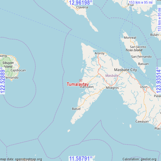
Tumalaytay GPS coordinates[2]
12° 16' 33.024" North, 123° 13' 55.236" East
| Map corner | latitude | longitude |
|---|---|---|
| Upper-left | 12.96198°, | 122.52889° |
| Center: | 12.27584°, | 123.23201° |
| Lower-right: | 11.58791°, | 123.93514° |
| Map W x H: | 152.8×152.8 km | = 94.9×94.9mi |
| max Lat: | 20.78733° ⇑46.8% North |
| Tumalaytay: | 12.27584° |
| min Lat: | ⇓53.2% South 4.65442° |
| min Long | Tumalaytay | max Long |
| 117.04868° | 123.23201° | 126.58417° |
| W 57.1%⇐ | ⇒42.9% E |
Elevation
Elevation of Tumalaytay is 12 m = 39 ft, and this is 75.9 m = 249 ft below average elevation for this country.
| Max E: |
2262 m = 7421 ft | 70.2% |
| Avg. | 87.9 m = 288 ft | |
| Tumalaytay | 12 m = 39 ft | |
Min E: |
-2 m = -7 ft | 29.8% |
See also: Philippines elevation on elevation.city.
Geographical zone
Tumalaytay is located in North Torrid zone (between Equator and Tropic of Cancer). Distance of this Northern Tropic circle is 1241 km =771.1 mi to North.| Distance of | km | miles | from Tumalaytay |
|---|---|---|---|
| North Pole | 8642.1 | 5370 | to North |
| Arctic Circle | 6036.2 | 3750.7 | to North |
| Tropic Cancer | 1241 | 771.1 | to North |
| Equator | 1364.9 | 848.1 | to South |


Nearby cities:
15 places around Tumalaytay: (largest is in red/bold)
• Aroroy
31.7 km =19.7 mi,  34°
34°
• Bacolod
30.5 km =19 mi,  99°
99°
• Balud
26.9 km =16.7 mi,  188°
188°
• Bangad
22.4 km =13.9 mi,  124°
124°
• Cabitan
12 km =7.5 mi,  80°
80°
• Calachuchi
33.1 km =20.6 mi, 101°
• Canomoy
13.8 km =8.6 mi,  162°
162°
• Lantangan
9.6 km =6 mi,  153°
153°
• Mandaon
7.9 km =4.9 mi,  134°
134°
• Milagros
30.8 km =19.1 mi, 102°
• Panguiranan
24.8 km =15.4 mi, 157°
• Paniqui
25.6 km =15.9 mi,  39°
39°
• Potot
23.2 km =14.4 mi,  110°
110°
• Puro
28.4 km =17.6 mi, 35°
• Tigbao
33.1 km =20.6 mi,  20°
20°
Sources, notices
• [Note1] Compared only with cities in Philippines existing in our database
• [Src1] Map data: © OpenStreetMap contributors (CC-BY-SA)
• [Src2] Other city data from geonames.org with taken over terms of usage.
• [Src3] Geographical zone / Annual Mean Temperature by Robert A. Rohde @ Wikipedia
