Aroroy geodata
Aroroy (Bicol) is a seat of a third-order administrative division; located in Philippines in Asia/Manila (GMT+8) time zone. With population of 3,513 people, there are 2047 cities with bigger population in this country. Compared to other cities in Philippines, 54.9% of cities are located further ↓South; 60.2% of cities are located further ←West and 92.7% of cities have higher elevation than Aroroy. Note1


Aroroy GPS coordinates[2]
12° 30' 39.96" North, 123° 23' 51.72" East
| Map corner | latitude | longitude |
|---|---|---|
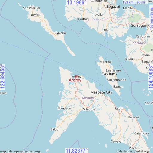
| Upper-left | 13.1966°, | 122.69458° |
| Center: | 12.5111°, | 123.3977° |
| Lower-right: | 11.82377°, | 124.10083° |
| Map W x H: | 152.6×152.6 km | = 94.8×94.8mi |
| max Lat: | 20.78733° ⇑45.1% North |
| Aroroy: | 12.5111° |
| min Lat: | ⇓54.9% South 4.65442° |
| min Long | Aroroy | max Long |
| 117.04868° | 123.3977° | 126.58417° |
| W 60.2%⇐ | ⇒39.8% E |
Elevation
Elevation of Aroroy is 6 m = 20 ft, and this is 81.9 m = 269 ft below average elevation for this country.
| Max E: |
2262 m = 7421 ft | 92.7% |
| Avg. | 87.9 m = 288 ft | |
| Aroroy | 6 m = 20 ft | |
Min E: |
-2 m = -7 ft | 7.3% |
See also: Philippines elevation on elevation.city.
Geographical zone
Aroroy is located in North Torrid zone (between Equator and Tropic of Cancer). Distance of this Northern Tropic circle is 1214.8 km =754.8 mi to North.| Distance of | km | miles | from Aroroy |
|---|---|---|---|
| North Pole | 8616 | 5353.7 | to North |
| Arctic Circle | 6010.1 | 3734.5 | to North |
| Tropic Cancer | 1214.8 | 754.8 | to North |
| Equator | 1391.1 | 864.4 | to South |


Nearby cities:
15 places around Aroroy: (largest is in red/bold)
• Bacolod
33.6 km =20.9 mi,  159°
159°
• Bagahanlad
30.4 km =18.9 mi,  75°
75°
• Baleno
11.7 km =7.3 mi,  110°
110°
• Bulo
21.5 km =13.4 mi,  121°
121°
• Cabitan
24.9 km =15.5 mi,  194°
194°
• Malinta
29.1 km =18.1 mi,  143°
143°
• Masbate
29.1 km =18.1 mi, 122°
• Mayngaran
28.4 km =17.6 mi,  129°
129°
• Monreal
32.5 km =20.2 mi,  62°
62°
• Osmeña
25.5 km =15.8 mi,  343°
343°
• Paniqui
6.7 km =4.2 mi, 194°
• Puro
3.4 km =2.1 mi,  208°
208°
• Tigbao
8 km =5 mi,  307°
307°
• Tumalaytay
31.7 km =19.7 mi, 214°
• Usab
28.3 km =17.6 mi, 135°
Sources, notices
• [Note1] Compared only with cities in Philippines existing in our database
• [Src1] Map data: © OpenStreetMap contributors (CC-BY-SA)
• [Src2] Other city data from geonames.org with taken over terms of usage.
• [Src3] Geographical zone / Annual Mean Temperature by Robert A. Rohde @ Wikipedia
