Tiguisan geodata
Tiguisan (Mimaropa) is a populated place; located in Philippines in Asia/Manila (GMT+8) time zone. With population of 2,486 people, there are 3316 cities with bigger population in this country. Compared to other cities in Philippines, 56.6% of cities are located further ↓South; 67.3% of cities are located further →East and 65.1% of cities have higher elevation than Tiguisan. Note1


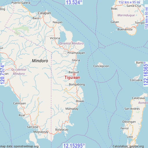
Tiguisan GPS coordinates[2]
12° 50' 21.876" North, 121° 27' 37.872" East
| Map corner | latitude | longitude |
|---|---|---|
| Upper-left | 13.524°, | 120.7574° |
| Center: | 12.83941°, | 121.46052° |
| Lower-right: | 12.15295°, | 122.16365° |
| Map W x H: | 152.4×152.5 km | = 94.7×94.8mi |
| max Lat: | 20.78733° ⇑43.4% North |
| Tiguisan: | 12.83941° |
| min Lat: | ⇓56.6% South 4.65442° |
| min Long | Tiguisan | max Long |
| 117.04868° | 121.46052° | 126.58417° |
| W 32.7%⇐ | ⇒67.3% E |
Elevation
Elevation of Tiguisan is 14 m = 46 ft, and this is 73.9 m = 242 ft below average elevation for this country.
| Max E: |
2262 m = 7421 ft | 65.1% |
| Avg. | 87.9 m = 288 ft | |
| Tiguisan | 14 m = 46 ft | |
Min E: |
-2 m = -7 ft | 34.9% |
See also: Philippines elevation on elevation.city.
Geographical zone
Tiguisan is located in North Torrid zone (between Equator and Tropic of Cancer). Distance of this Northern Tropic circle is 1178.3 km =732.2 mi to North.| Distance of | km | miles | from Tiguisan |
|---|---|---|---|
| North Pole | 8579.5 | 5331.1 | to North |
| Arctic Circle | 5973.6 | 3711.8 | to North |
| Tropic Cancer | 1178.3 | 732.2 | to North |
| Equator | 1427.6 | 887.1 | to South |


Nearby cities:
15 places around Tiguisan: (largest is in red/bold)
• Anilao
15 km =9.3 mi,  158°
158°
• Bansud
2.9 km =1.8 mi,  351°
351°
• Calamundingan
10.2 km =6.3 mi,  6°
6°
• Gloria
16 km =9.9 mi,  2°
2°
• Labasan
7 km =4.3 mi,  172°
172°
• Malamig
16 km =9.9 mi,  320°
320°
• Malitbog
9.7 km =6 mi,  176°
176°
• Masaguisi
9.5 km =5.9 mi,  187°
187°
• Pambisan
20.1 km =12.5 mi, 345°
• Quinabigan
17.3 km =10.7 mi, 6°
• Sagana
13.3 km =8.3 mi, 167°
• Salcedo
3.3 km =2.1 mi, 166°
• San Mariano
22.1 km =13.7 mi, 186°
• Sumagui
5.1 km =3.2 mi, 163°
• Tambong
14.1 km =8.8 mi, 10°
Sources, notices
• [Note1] Compared only with cities in Philippines existing in our database
• [Src1] Map data: © OpenStreetMap contributors (CC-BY-SA)
• [Src2] Other city data from geonames.org with taken over terms of usage.
• [Src3] Geographical zone / Annual Mean Temperature by Robert A. Rohde @ Wikipedia
