Sumabnit geodata
Sumabnit (Ilocos) is a populated place; located in Philippines in Asia/Manila (GMT+8) time zone. With population of 4,296 people, there are 1588 cities with bigger population in this country. Compared to other cities in Philippines, 88% of cities are located further ↓South; 88.7% of cities are located further →East and 59.5% of cities have lower elevation than Sumabnit. Note1


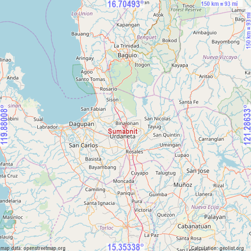
Sumabnit GPS coordinates[2]
16° 1' 49.08" North, 120° 34' 59.52" East
| Map corner | latitude | longitude |
|---|---|---|
| Upper-left | 16.70493°, | 119.88008° |
| Center: | 16.0303°, | 120.5832° |
| Lower-right: | 15.35338°, | 121.28633° |
| Map W x H: | 150.3×150.3 km | = 93.4×93.4mi |
| max Lat: | 20.78733° ⇑12% North |
| Sumabnit: | 16.0303° |
| min Lat: | ⇓88% South 4.65442° |
| min Long | Sumabnit | max Long |
| 117.04868° | 120.5832° | 126.58417° |
| W 11.3%⇐ | ⇒88.7% E |
Elevation
Elevation of Sumabnit is 33 m = 108 ft, and this is 54.9 m = 180 ft below average elevation for this country.
| Max E: |
2262 m = 7421 ft | 40.5% |
| Avg. | 87.9 m = 288 ft | |
| Sumabnit | 33 m = 108 ft | |
Min E: |
-2 m = -7 ft | 59.5% |
See also: Philippines elevation on elevation.city.
Geographical zone
Sumabnit is located in North Torrid zone (between Equator and Tropic of Cancer). Distance of this Northern Tropic circle is 823.5 km =511.7 mi to North.| Distance of | km | miles | from Sumabnit |
|---|---|---|---|
| North Pole | 8224.7 | 5110.6 | to North |
| Arctic Circle | 5618.8 | 3491.4 | to North |
| Tropic Cancer | 823.5 | 511.7 | to North |
| Equator | 1782.4 | 1107.5 | to South |


Nearby cities:
15 places around Sumabnit: (largest is in red/bold)
• Amagbagan
9.3 km =5.8 mi,  316°
316°
• Asingan
9.6 km =6 mi,  106°
106°
• Bactad Proper
6.5 km =4 mi,  153°
153°
• Baro
10.3 km =6.4 mi, 109°
• Binalonan
2.4 km =1.5 mi,  24°
24°
• Calepaan
4 km =2.5 mi, 107°
• Carusucan
9.1 km =5.7 mi,  141°
141°
• Dilan
9.3 km =5.8 mi,  313°
313°
• Domampot
7.9 km =4.9 mi,  115°
115°
• Gueset
10.4 km =6.5 mi, 149°
• Macalong
8.3 km =5.2 mi,  102°
102°
• Pozorrubio
9.9 km =6.2 mi,  334°
334°
• San Manuel
9.9 km =6.2 mi,  67°
67°
• Toboy
5.7 km =3.5 mi,  93°
93°
• Urdaneta
6.2 km =3.9 mi,  192°
192°
Sources, notices
• [Note1] Compared only with cities in Philippines existing in our database
• [Src1] Map data: © OpenStreetMap contributors (CC-BY-SA)
• [Src2] Other city data from geonames.org with taken over terms of usage.
• [Src3] Geographical zone / Annual Mean Temperature by Robert A. Rohde @ Wikipedia
