Bactad Proper geodata
Bactad Proper (Ilocos) is a populated place; located in Philippines in Asia/Manila (GMT+8) time zone. With population of 3,610 people, there are 1974 cities with bigger population in this country. Compared to other cities in Philippines, 87.1% of cities are located further ↓South; 87.8% of cities are located further →East and 59.5% of cities have lower elevation than Bactad Proper. Note1
Administrative division(s):
- Level 1: Ilocos
- Level 2: Province of Pangasinan
- Level 3: City of Urdaneta


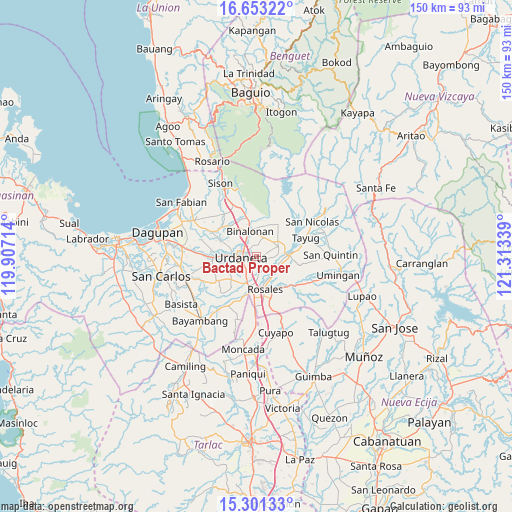
Bactad Proper GPS coordinates[2]
15° 58' 42.312" North, 120° 36' 36.936" East
| Map corner | latitude | longitude |
|---|---|---|
| Upper-left | 16.65322°, | 119.90714° |
| Center: | 15.97842°, | 120.61026° |
| Lower-right: | 15.30133°, | 121.31339° |
| Map W x H: | 150.3×150.3 km | = 93.4×93.4mi |
| max Lat: | 20.78733° ⇑12.9% North |
| Bactad Proper: | 15.97842° |
| min Lat: | ⇓87.1% South 4.65442° |
| min Long | Bactad Proper | max Long |
| 117.04868° | 120.61026° | 126.58417° |
| W 12.2%⇐ | ⇒87.8% E |
Elevation
Elevation of Bactad Proper is 33 m = 108 ft, and this is 54.9 m = 180 ft below average elevation for this country.
| Max E: |
2262 m = 7421 ft | 40.5% |
| Avg. | 87.9 m = 288 ft | |
| Bactad Proper | 33 m = 108 ft | |
Min E: |
-2 m = -7 ft | 59.5% |
See also: Philippines elevation on elevation.city.
Geographical zone
Bactad Proper is located in North Torrid zone (between Equator and Tropic of Cancer). Distance of this Northern Tropic circle is 829.3 km =515.3 mi to North.| Distance of | km | miles | from Bactad Proper |
|---|---|---|---|
| North Pole | 8230.4 | 5114.1 | to North |
| Arctic Circle | 5624.5 | 3494.9 | to North |
| Tropic Cancer | 829.3 | 515.3 | to North |
| Equator | 1776.6 | 1103.9 | to South |


Nearby cities:
15 places around Bactad Proper: (largest is in red/bold)
• Asingan
7 km =4.3 mi,  64°
64°
• Bacag
6.2 km =3.9 mi,  209°
209°
• Baro
7.1 km =4.4 mi,  71°
71°
• Binalonan
8.2 km =5.1 mi,  346°
346°
• Calepaan
4.7 km =2.9 mi,  11°
11°
• Caramutan
6.4 km =4 mi,  180°
180°
• Carusucan
3.1 km =1.9 mi,  116°
116°
• Domampot
4.9 km =3 mi, 60°
• Gueset
4 km =2.5 mi,  142°
142°
• Macalong
6.5 km =4 mi,  52°
52°
• Samon
6.5 km =4 mi, 138°
• Sumabnit
6.5 km =4 mi,  333°
333°
• Toboy
6.1 km =3.8 mi,  27°
27°
• Tombod
6.9 km =4.3 mi,  221°
221°
• Urdaneta
4.2 km =2.6 mi,  266°
266°
Sources, notices
• [Note1] Compared only with cities in Philippines existing in our database
• [Src1] Map data: © OpenStreetMap contributors (CC-BY-SA)
• [Src2] Other city data from geonames.org with taken over terms of usage.
• [Src3] Geographical zone / Annual Mean Temperature by Robert A. Rohde @ Wikipedia
