Sogod geodata
Sogod (Eastern Visayas) is a seat of a third-order administrative division; located in Philippines in Asia/Manila (GMT+8) time zone. With population of 8,303 people, there are 745 cities with bigger population in this country. Compared to other cities in Philippines, 64.3% of cities are located further ↑North; 87.3% of cities are located further ←West and 76.6% of cities have higher elevation than Sogod. Note1
Administrative division(s):
- Level 1: Eastern Visayas
- Level 2: Province of Southern Leyte
- Level 3: Sogod


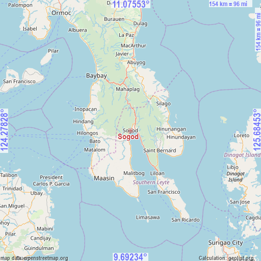
Sogod GPS coordinates[2]
10° 23' 4.92" North, 124° 58' 53.04" East
| Map corner | latitude | longitude |
|---|---|---|
| Upper-left | 11.07553°, | 124.27828° |
| Center: | 10.3847°, | 124.9814° |
| Lower-right: | 9.69234°, | 125.68453° |
| Map W x H: | 153.8×153.8 km | = 95.6×95.6mi |
| max Lat: | 20.78733° ⇑64.3% North |
| Sogod: | 10.3847° |
| min Lat: | ⇓35.7% South 4.65442° |
| min Long | Sogod | max Long |
| 117.04868° | 124.9814° | 126.58417° |
| W 87.3%⇐ | ⇒12.7% E |
Elevation
Elevation of Sogod is 10 m = 33 ft, and this is 77.9 m = 256 ft below average elevation for this country.
| Max E: |
2262 m = 7421 ft | 76.6% |
| Avg. | 87.9 m = 288 ft | |
| Sogod | 10 m = 33 ft | |
Min E: |
-2 m = -7 ft | 23.4% |
See also: Philippines elevation on elevation.city.
Geographical zone
Sogod is located in North Torrid zone (between Equator and Tropic of Cancer). Distance of Equator is 1154.7 km =717.5 mi to South.| Distance of | km | miles | from Sogod |
|---|---|---|---|
| North Pole | 8852.4 | 5500.6 | to North |
| Arctic Circle | 6246.5 | 3881.4 | to North |
| Tropic Cancer | 1451.2 | 901.7 | to North |
| Equator | 1154.7 | 717.5 | to South |


Nearby cities:
15 places around Sogod: (largest is in red/bold)
• Anahawan
12.2 km =7.6 mi,  247°
247°
• Bato
21.8 km =13.5 mi, 253°
• Bontoc
3.5 km =2.2 mi,  201°
201°
• Concepcion
21.8 km =13.5 mi,  276°
276°
• Hinunangan
23.7 km =14.7 mi,  87°
87°
• Libagon
12.4 km =7.7 mi,  138°
138°
• Mahaplag
24.5 km =15.2 mi,  355°
355°
• Malitbog
25.1 km =15.6 mi,  175°
175°
• Matalom
24 km =14.9 mi,  241°
241°
• Polahongon
16.1 km =10 mi, 355°
• Saint Bernard
24.8 km =15.4 mi,  117°
117°
• San Juan
25 km =15.5 mi, 121°
• Santa Paz
25.3 km =15.7 mi, 238°
• Tabonoc
20.2 km =12.6 mi,  258°
258°
• Tomas Oppus
14.9 km =9.3 mi, 179°
Sources, notices
• [Note1] Compared only with cities in Philippines existing in our database
• [Src1] Map data: © OpenStreetMap contributors (CC-BY-SA)
• [Src2] Other city data from geonames.org with taken over terms of usage.
• [Src3] Geographical zone / Annual Mean Temperature by Robert A. Rohde @ Wikipedia
