San Esteban geodata
San Esteban (Ilocos) is a seat of a third-order administrative division; located in Philippines in Asia/Manila (GMT+8) time zone. In our database, there are 4166 cities with bigger population. Compared to other cities in Philippines, 95.2% of cities are located further ↓South; 92.4% of cities are located further →East and 76.6% of cities have higher elevation than San Esteban. Note1


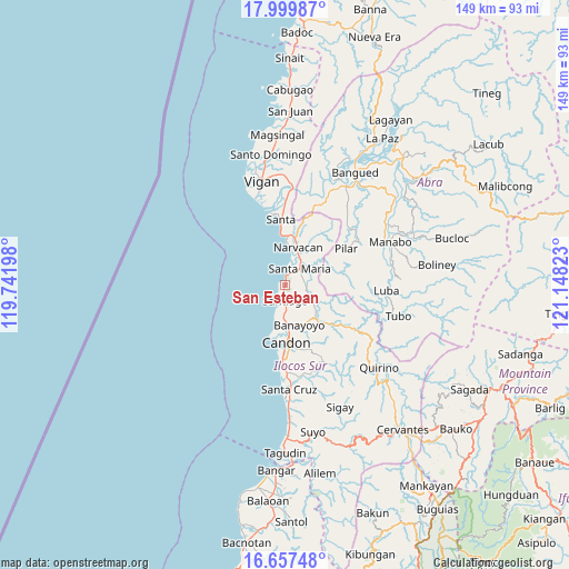
San Esteban GPS coordinates[2]
17° 19' 47.64" North, 120° 26' 42.36" East
| Map corner | latitude | longitude |
|---|---|---|
| Upper-left | 17.99987°, | 119.74198° |
| Center: | 17.3299°, | 120.4451° |
| Lower-right: | 16.65748°, | 121.14823° |
| Map W x H: | 149.3×149.3 km | = 92.8×92.8mi |
| max Lat: | 20.78733° ⇑4.8% North |
| San Esteban: | 17.3299° |
| min Lat: | ⇓95.2% South 4.65442° |
| min Long | San Esteban | max Long |
| 117.04868° | 120.4451° | 126.58417° |
| W 7.6%⇐ | ⇒92.4% E |
Elevation
Elevation of San Esteban is 10 m = 33 ft, and this is 77.9 m = 256 ft below average elevation for this country.
| Max E: |
2262 m = 7421 ft | 76.6% |
| Avg. | 87.9 m = 288 ft | |
| San Esteban | 10 m = 33 ft | |
Min E: |
-2 m = -7 ft | 23.4% |
See also: Philippines elevation on elevation.city.
Geographical zone
San Esteban is located in North Torrid zone (between Equator and Tropic of Cancer). Distance of this Northern Tropic circle is 679 km =421.9 mi to North.| Distance of | km | miles | from San Esteban |
|---|---|---|---|
| North Pole | 8080.2 | 5020.8 | to North |
| Arctic Circle | 5474.3 | 3401.6 | to North |
| Tropic Cancer | 679 | 421.9 | to North |
| Equator | 1926.9 | 1197.3 | to South |


Nearby cities:
15 places around San Esteban: (largest is in red/bold)
• Banayoyo
11.5 km =7.1 mi,  159°
159°
• Burgos
5.3 km =3.3 mi,  87°
87°
• Candon
15 km =9.3 mi,  177°
177°
• Caterman
12.7 km =7.9 mi,  189°
189°
• Darapidap
14.7 km =9.1 mi, 191°
• Lidlidda
10.5 km =6.5 mi,  129°
129°
• Lungog
15.4 km =9.6 mi,  13°
13°
• Nagbukel
15.5 km =9.6 mi,  32°
32°
• Narvacan
10.3 km =6.4 mi,  18°
18°
• Quinarayan
13 km =8.1 mi, 12°
• Santa Maria
5.6 km =3.5 mi,  42°
42°
• Santiago
4 km =2.5 mi, 180°
• Suso
3.7 km =2.3 mi, 27°
• Tablac
12.7 km =7.9 mi, 175°
• Tamorong
1.3 km =0.8 mi,  286°
286°
Sources, notices
• [Note1] Compared only with cities in Philippines existing in our database
• [Src1] Map data: © OpenStreetMap contributors (CC-BY-SA)
• [Src2] Other city data from geonames.org with taken over terms of usage.
• [Src3] Geographical zone / Annual Mean Temperature by Robert A. Rohde @ Wikipedia
