Maasim geodata
Maasim (Soccsksargen) is a populated place; located in Philippines in Asia/Manila (GMT+8) time zone. With population of 5,847 people, there are 1076 cities with bigger population in this country. Compared to other cities in Philippines, 98.9% of cities are located further ↑North; 87.7% of cities are located further ←West and 95.5% of cities have higher elevation than Maasim. Note1


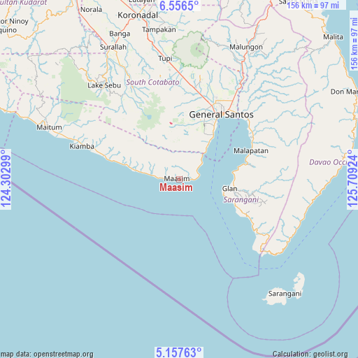
Maasim GPS coordinates[2]
5° 51' 27" North, 125° 0' 21.996" East
| Map corner | latitude | longitude |
|---|---|---|
| Upper-left | 6.5565°, | 124.30299° |
| Center: | 5.8575°, | 125.00611° |
| Lower-right: | 5.15763°, | 125.70924° |
| Map W x H: | 155.5×155.5 km | = 96.6×96.6mi |
| max Lat: | 20.78733° ⇑98.9% North |
| Maasim: | 5.8575° |
| min Lat: | ⇓1.1% South 4.65442° |
| min Long | Maasim | max Long |
| 117.04868° | 125.00611° | 126.58417° |
| W 87.7%⇐ | ⇒12.3% E |
Elevation
Elevation of Maasim is 5 m = 16 ft, and this is 82.9 m = 272 ft below average elevation for this country.
| Max E: |
2262 m = 7421 ft | 95.5% |
| Avg. | 87.9 m = 288 ft | |
| Maasim | 5 m = 16 ft | |
Min E: |
-2 m = -7 ft | 4.5% |
See also: Philippines elevation on elevation.city.
Geographical zone
Maasim is located in North Torrid zone (between Equator and Tropic of Cancer). Distance of Equator is 651.3 km =404.7 mi to South.| Distance of | km | miles | from Maasim |
|---|---|---|---|
| North Pole | 9355.8 | 5813.4 | to North |
| Arctic Circle | 6749.9 | 4194.2 | to North |
| Tropic Cancer | 1954.6 | 1214.5 | to North |
| Equator | 651.3 | 404.7 | to South |


Nearby cities:
15 places around Maasim: (largest is in red/bold)
• Daliao
5.9 km =3.7 mi,  273°
273°
• Glan
22.1 km =13.7 mi,  99°
99°
• Glan Peidu
23.5 km =14.6 mi,  90°
90°
• Ilaya
24.8 km =15.4 mi, 100°
• Kablalan
22.9 km =14.2 mi,  112°
112°
• Kamanga
5.5 km =3.4 mi, 89°
• Kapatan
26 km =16.2 mi,  79°
79°
• Katubao
19.9 km =12.4 mi,  280°
280°
• Lumatil
13.2 km =8.2 mi, 278°
• Lumazal
17.6 km =10.9 mi, 280°
• Lumuyon
25.1 km =15.6 mi, 284°
• Malbang
4.3 km =2.7 mi, 92°
• Taluya
19.1 km =11.9 mi, 105°
• Tañgo
24 km =14.9 mi, 83°
• Tinoto
7.8 km =4.8 mi,  65°
65°
Sources, notices
• [Note1] Compared only with cities in Philippines existing in our database
• [Src1] Map data: © OpenStreetMap contributors (CC-BY-SA)
• [Src2] Other city data from geonames.org with taken over terms of usage.
• [Src3] Geographical zone / Annual Mean Temperature by Robert A. Rohde @ Wikipedia
