Kapatan geodata
Kapatan (Soccsksargen) is a populated place; located in Philippines in Asia/Manila (GMT+8) time zone. With population of 2,902 people, there are 2643 cities with bigger population in this country. Compared to other cities in Philippines, 98.7% of cities are located further ↑North; 90.6% of cities are located further ←West and 54.4% of cities have lower elevation than Kapatan. Note1


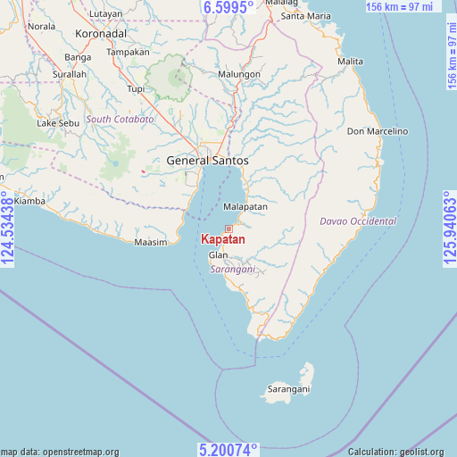
Kapatan GPS coordinates[2]
5° 54' 2.016" North, 125° 14' 15" East
| Map corner | latitude | longitude |
|---|---|---|
| Upper-left | 6.5995°, | 124.53438° |
| Center: | 5.90056°, | 125.2375° |
| Lower-right: | 5.20074°, | 125.94063° |
| Map W x H: | 155.5×155.5 km | = 96.6×96.6mi |
| max Lat: | 20.78733° ⇑98.7% North |
| Kapatan: | 5.90056° |
| min Lat: | ⇓1.3% South 4.65442° |
| min Long | Kapatan | max Long |
| 117.04868° | 125.2375° | 126.58417° |
| W 90.6%⇐ | ⇒9.4% E |
Elevation
Elevation of Kapatan is 27 m = 89 ft, and this is 60.9 m = 200 ft below average elevation for this country.
| Max E: |
2262 m = 7421 ft | 45.6% |
| Avg. | 87.9 m = 288 ft | |
| Kapatan | 27 m = 89 ft | |
Min E: |
-2 m = -7 ft | 54.4% |
See also: Philippines elevation on elevation.city.
Geographical zone
Kapatan is located in North Torrid zone (between Equator and Tropic of Cancer). Distance of Equator is 656.1 km =407.7 mi to South.| Distance of | km | miles | from Kapatan |
|---|---|---|---|
| North Pole | 9351 | 5810.4 | to North |
| Arctic Circle | 6745.1 | 4191.2 | to North |
| Tropic Cancer | 1949.8 | 1211.5 | to North |
| Equator | 656.1 | 407.7 | to South |


Nearby cities:
15 places around Kapatan: (largest is in red/bold)
• Baliton
17.5 km =10.9 mi,  180°
180°
• Burias
20.4 km =12.7 mi,  174°
174°
• Glan
9.3 km =5.8 mi,  203°
203°
• Glan Peidu
5.5 km =3.4 mi, 202°
• Ilaya
9.6 km =6 mi,  187°
187°
• Kablalan
14.1 km =8.8 mi, 198°
• Kamanga
20.6 km =12.8 mi,  256°
256°
• Kiupo
11.2 km =7 mi,  125°
125°
• Lun Pequeño
16.1 km =10 mi,  18°
18°
• Malapatan
9.5 km =5.9 mi,  36°
36°
• Sapu Padidu
3.7 km =2.3 mi,  60°
60°
• Taluya
12.2 km =7.6 mi,  215°
215°
• Tañgo
2.8 km =1.7 mi, 218°
• Tinoto
18.5 km =11.5 mi,  265°
265°
• Tuyan
12.2 km =7.6 mi, 24°
Sources, notices
• [Note1] Compared only with cities in Philippines existing in our database
• [Src1] Map data: © OpenStreetMap contributors (CC-BY-SA)
• [Src2] Other city data from geonames.org with taken over terms of usage.
• [Src3] Geographical zone / Annual Mean Temperature by Robert A. Rohde @ Wikipedia
