Lunao geodata
Lunao (Northern Mindanao) is a populated place; located in Philippines in Asia/Manila (GMT+8) time zone. With population of 8,995 people, there are 689 cities with bigger population in this country. Compared to other cities in Philippines, 76.7% of cities are located further ↑North; 88.9% of cities are located further ←West and 76.6% of cities have higher elevation than Lunao. Note1
Administrative division(s):
- Level 1: Northern Mindanao
- Level 2: Province of Misamis Oriental
- Level 3: Gingoog City


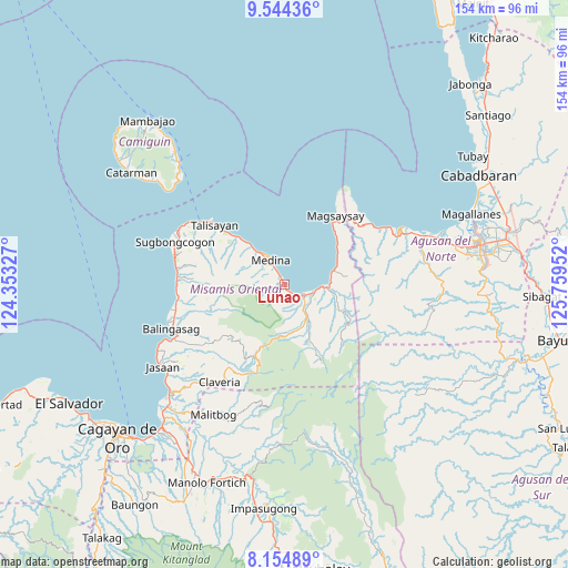
Lunao GPS coordinates[2]
8° 51' 1.008" North, 125° 3' 23.004" East
| Map corner | latitude | longitude |
|---|---|---|
| Upper-left | 9.54436°, | 124.35327° |
| Center: | 8.85028°, | 125.05639° |
| Lower-right: | 8.15489°, | 125.75952° |
| Map W x H: | 154.5×154.5 km | = 96×96mi |
| max Lat: | 20.78733° ⇑76.7% North |
| Lunao: | 8.85028° |
| min Lat: | ⇓23.3% South 4.65442° |
| min Long | Lunao | max Long |
| 117.04868° | 125.05639° | 126.58417° |
| W 88.9%⇐ | ⇒11.1% E |
Elevation
Elevation of Lunao is 10 m = 33 ft, and this is 77.9 m = 256 ft below average elevation for this country.
| Max E: |
2262 m = 7421 ft | 76.6% |
| Avg. | 87.9 m = 288 ft | |
| Lunao | 10 m = 33 ft | |
Min E: |
-2 m = -7 ft | 23.4% |
See also: Philippines elevation on elevation.city.
Geographical zone
Lunao is located in North Torrid zone (between Equator and Tropic of Cancer). Distance of Equator is 984.1 km =611.5 mi to South.| Distance of | km | miles | from Lunao |
|---|---|---|---|
| North Pole | 9023 | 5606.6 | to North |
| Arctic Circle | 6417.1 | 3987.4 | to North |
| Tropic Cancer | 1621.9 | 1007.8 | to North |
| Equator | 984.1 | 611.5 | to South |


Nearby cities:
15 places around Lunao: (largest is in red/bold)
• Anakan
10.4 km =6.5 mi,  91°
91°
• Balingoan
28.2 km =17.5 mi,  307°
307°
• Candiis
19.4 km =12.1 mi,  46°
46°
• Consuelo
15.5 km =9.6 mi,  68°
68°
• Kibonsod
24.2 km =15 mi,  43°
43°
• Maanas
5.6 km =3.5 mi,  329°
329°
• Magsaysay
23.5 km =14.6 mi, 36°
• Malinaw
15.3 km =9.5 mi,  100°
100°
• Mananum
11.8 km =7.3 mi,  260°
260°
• Mariano
6.9 km =4.3 mi,  105°
105°
• Medina
7.7 km =4.8 mi, 332°
• Minlagas
3.7 km =2.3 mi, 328°
• Odiongan
12.1 km =7.5 mi, 92°
• Tagcatong
27.8 km =17.3 mi, 52°
• Talisayan
25.5 km =15.8 mi, 310°
Sources, notices
• [Note1] Compared only with cities in Philippines existing in our database
• [Src1] Map data: © OpenStreetMap contributors (CC-BY-SA)
• [Src2] Other city data from geonames.org with taken over terms of usage.
• [Src3] Geographical zone / Annual Mean Temperature by Robert A. Rohde @ Wikipedia
