Lagonoy geodata
Lagonoy (Bicol) is a seat of a third-order administrative division; located in Philippines in Asia/Manila (GMT+8) time zone. With population of 7,324 people, there are 851 cities with bigger population in this country. Compared to other cities in Philippines, 64.7% of cities are located further ↓South; 62.7% of cities are located further ←West and 62.8% of cities have higher elevation than Lagonoy. Note1


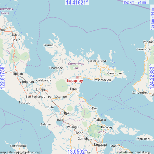
Lagonoy GPS coordinates[2]
13° 44' 3.12" North, 123° 31' 14.52" East
| Map corner | latitude | longitude |
|---|---|---|
| Upper-left | 14.41621°, | 122.81758° |
| Center: | 13.7342°, | 123.5207° |
| Lower-right: | 13.0502°, | 124.22383° |
| Map W x H: | 151.9×151.9 km | = 94.4×94.4mi |
| max Lat: | 20.78733° ⇑35.3% North |
| Lagonoy: | 13.7342° |
| min Lat: | ⇓64.7% South 4.65442° |
| min Long | Lagonoy | max Long |
| 117.04868° | 123.5207° | 126.58417° |
| W 62.7%⇐ | ⇒37.3% E |
Elevation
Elevation of Lagonoy is 15 m = 49 ft, and this is 72.9 m = 239 ft below average elevation for this country.
| Max E: |
2262 m = 7421 ft | 62.8% |
| Avg. | 87.9 m = 288 ft | |
| Lagonoy | 15 m = 49 ft | |
Min E: |
-2 m = -7 ft | 37.2% |
See also: Philippines elevation on elevation.city.
Geographical zone
Lagonoy is located in North Torrid zone (between Equator and Tropic of Cancer). Distance of this Northern Tropic circle is 1078.8 km =670.3 mi to North.| Distance of | km | miles | from Lagonoy |
|---|---|---|---|
| North Pole | 8480 | 5269.2 | to North |
| Arctic Circle | 5874.1 | 3650 | to North |
| Tropic Cancer | 1078.8 | 670.3 | to North |
| Equator | 1527.1 | 948.9 | to South |


Nearby cities:
15 places around Lagonoy: (largest is in red/bold)
• Buracan
15.1 km =9.4 mi,  188°
188°
• Buyo
7.8 km =4.8 mi,  221°
221°
• Caraycayon
13.7 km =8.5 mi,  197°
197°
• Goa
5.3 km =3.3 mi, 220°
• Kinalansan
4.9 km =3 mi,  134°
134°
• Nato
13.8 km =8.6 mi,  173°
173°
• Sabang
6.4 km =4 mi,  102°
102°
• Sagnay
14.6 km =9.1 mi,  179°
179°
• Salogon
8.4 km =5.2 mi, 178°
• Salvacion
15.6 km =9.7 mi, 198°
• San Jose
3.9 km =2.4 mi, 184°
• San Ramon
2.5 km =1.6 mi,  122°
122°
• San Sebastian
7.9 km =4.9 mi,  94°
94°
• Tigaon
11.5 km =7.1 mi, 192°
• Tinawagan
10.2 km =6.3 mi, 203°
Sources, notices
• [Note1] Compared only with cities in Philippines existing in our database
• [Src1] Map data: © OpenStreetMap contributors (CC-BY-SA)
• [Src2] Other city data from geonames.org with taken over terms of usage.
• [Src3] Geographical zone / Annual Mean Temperature by Robert A. Rohde @ Wikipedia
