Salvacion geodata
Salvacion (Bicol) is a populated place; located in Philippines in Asia/Manila (GMT+8) time zone. With population of 2,494 people, there are 3303 cities with bigger population in this country. Compared to other cities in Philippines, 63.3% of cities are located further ↓South; 61.7% of cities are located further ←West and 72.2% of cities have lower elevation than Salvacion. Note1


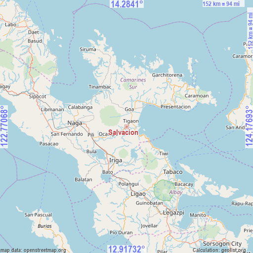
Salvacion GPS coordinates[2]
13° 36' 6.12" North, 123° 28' 25.68" East
| Map corner | latitude | longitude |
|---|---|---|
| Upper-left | 14.2841°, | 122.77068° |
| Center: | 13.6017°, | 123.4738° |
| Lower-right: | 12.91732°, | 124.17693° |
| Map W x H: | 152×152 km | = 94.4×94.4mi |
| max Lat: | 20.78733° ⇑36.7% North |
| Salvacion: | 13.6017° |
| min Lat: | ⇓63.3% South 4.65442° |
| min Long | Salvacion | max Long |
| 117.04868° | 123.4738° | 126.58417° |
| W 61.7%⇐ | ⇒38.3% E |
Elevation
Elevation of Salvacion is 58 m = 190 ft, and this is 29.9 m = 98 ft below average elevation for this country.
| Max E: |
2262 m = 7421 ft | 27.8% |
| Avg. | 87.9 m = 288 ft | |
| Salvacion | 58 m = 190 ft | |
Min E: |
-2 m = -7 ft | 72.2% |
See also: Philippines elevation on elevation.city.
Geographical zone
Salvacion is located in North Torrid zone (between Equator and Tropic of Cancer). Distance of this Northern Tropic circle is 1093.6 km =679.5 mi to North.| Distance of | km | miles | from Salvacion |
|---|---|---|---|
| North Pole | 8494.7 | 5278.4 | to North |
| Arctic Circle | 5888.8 | 3659.1 | to North |
| Tropic Cancer | 1093.6 | 679.5 | to North |
| Equator | 1512.4 | 939.8 | to South |


Nearby cities:
15 places around Salvacion: (largest is in red/bold)
• Buracan
2.8 km =1.7 mi,  93°
93°
• Buyo
8.9 km =5.5 mi,  359°
359°
• Caraycayon
2 km =1.2 mi,  31°
31°
• Gatbo
10 km =6.2 mi,  258°
258°
• Goa
10.8 km =6.7 mi,  8°
8°
• Kinalansan
14.2 km =8.8 mi,  37°
37°
• Nato
6.7 km =4.2 mi,  81°
81°
• Ocampo
11.6 km =7.2 mi,  245°
245°
• Pinit
7.4 km =4.6 mi,  240°
240°
• Sagnay
5.3 km =3.3 mi, 88°
• Sagrada
8.3 km =5.2 mi,  195°
195°
• Salogon
8.2 km =5.1 mi, 39°
• San Jose
11.8 km =7.3 mi,  23°
23°
• Tigaon
4.3 km =2.7 mi, 35°
• Tinawagan
5.5 km =3.4 mi, 10°
Sources, notices
• [Note1] Compared only with cities in Philippines existing in our database
• [Src1] Map data: © OpenStreetMap contributors (CC-BY-SA)
• [Src2] Other city data from geonames.org with taken over terms of usage.
• [Src3] Geographical zone / Annual Mean Temperature by Robert A. Rohde @ Wikipedia
