Labney geodata
Labney (Ilocos) is a populated place; located in Philippines in Asia/Manila (GMT+8) time zone. With population of 2,150 people, there are 3988 cities with bigger population in this country. Compared to other cities in Philippines, 88.7% of cities are located further ↓South; 91.6% of cities are located further →East and 58.1% of cities have lower elevation than Labney. Note1


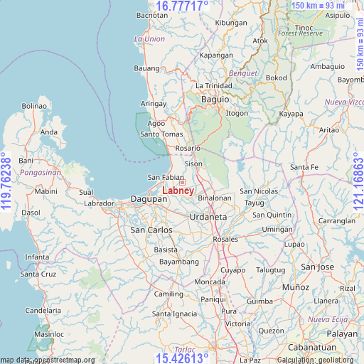
Labney GPS coordinates[2]
16° 6' 10.08" North, 120° 27' 55.8" East
| Map corner | latitude | longitude |
|---|---|---|
| Upper-left | 16.77717°, | 119.76238° |
| Center: | 16.1028°, | 120.4655° |
| Lower-right: | 15.42613°, | 121.16863° |
| Map W x H: | 150.2×150.2 km | = 93.3×93.3mi |
| max Lat: | 20.78733° ⇑11.3% North |
| Labney: | 16.1028° |
| min Lat: | ⇓88.7% South 4.65442° |
| min Long | Labney | max Long |
| 117.04868° | 120.4655° | 126.58417° |
| W 8.4%⇐ | ⇒91.6% E |
Elevation
Elevation of Labney is 31 m = 102 ft, and this is 56.9 m = 187 ft below average elevation for this country.
| Max E: |
2262 m = 7421 ft | 41.9% |
| Avg. | 87.9 m = 288 ft | |
| Labney | 31 m = 102 ft | |
Min E: |
-2 m = -7 ft | 58.1% |
See also: Philippines elevation on elevation.city.
Geographical zone
Labney is located in North Torrid zone (between Equator and Tropic of Cancer). Distance of this Northern Tropic circle is 815.5 km =506.7 mi to North.| Distance of | km | miles | from Labney |
|---|---|---|---|
| North Pole | 8216.6 | 5105.6 | to North |
| Arctic Circle | 5610.7 | 3486.3 | to North |
| Tropic Cancer | 815.5 | 506.7 | to North |
| Equator | 1790.5 | 1112.6 | to South |


Nearby cities:
15 places around Labney: (largest is in red/bold)
• Amagbagan
6.3 km =3.9 mi,  101°
101°
• Binday
3.1 km =1.9 mi,  333°
333°
• Bobonan
7.5 km =4.7 mi,  61°
61°
• Cayanga
7.3 km =4.5 mi,  280°
280°
• Dilan
6.1 km =3.8 mi,  105°
105°
• Lobong
2.4 km =1.5 mi,  167°
167°
• Longos
7.4 km =4.6 mi,  273°
273°
• Mabilao
7.1 km =4.4 mi,  322°
322°
• Macayug
3.7 km =2.3 mi,  254°
254°
• Manaoag
6.9 km =4.3 mi,  161°
161°
• Nibaliw Central
7.2 km =4.5 mi,  292°
292°
• Palacpalac
7.6 km =4.7 mi,  65°
65°
• Palguyod
6.2 km =3.9 mi, 69°
• San Fabian
6.8 km =4.2 mi, 289°
• San Jacinto
4.4 km =2.7 mi,  220°
220°
Sources, notices
• [Note1] Compared only with cities in Philippines existing in our database
• [Src1] Map data: © OpenStreetMap contributors (CC-BY-SA)
• [Src2] Other city data from geonames.org with taken over terms of usage.
• [Src3] Geographical zone / Annual Mean Temperature by Robert A. Rohde @ Wikipedia
