Lobong geodata
Lobong (Ilocos) is a populated place; located in Philippines in Asia/Manila (GMT+8) time zone. With population of 3,641 people, there are 1956 cities with bigger population in this country. Compared to other cities in Philippines, 88.5% of cities are located further ↓South; 91.5% of cities are located further →East and 56.6% of cities have lower elevation than Lobong. Note1


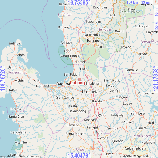
Lobong GPS coordinates[2]
16° 4' 53.4" North, 120° 28' 13.44" East
| Map corner | latitude | longitude |
|---|---|---|
| Upper-left | 16.75595°, | 119.76728° |
| Center: | 16.0815°, | 120.4704° |
| Lower-right: | 15.40476°, | 121.17353° |
| Map W x H: | 150.2×150.2 km | = 93.3×93.3mi |
| max Lat: | 20.78733° ⇑11.5% North |
| Lobong: | 16.0815° |
| min Lat: | ⇓88.5% South 4.65442° |
| min Long | Lobong | max Long |
| 117.04868° | 120.4704° | 126.58417° |
| W 8.5%⇐ | ⇒91.5% E |
Elevation
Elevation of Lobong is 29 m = 95 ft, and this is 58.9 m = 193 ft below average elevation for this country.
| Max E: |
2262 m = 7421 ft | 43.4% |
| Avg. | 87.9 m = 288 ft | |
| Lobong | 29 m = 95 ft | |
Min E: |
-2 m = -7 ft | 56.6% |
See also: Philippines elevation on elevation.city.
Geographical zone
Lobong is located in North Torrid zone (between Equator and Tropic of Cancer). Distance of this Northern Tropic circle is 817.8 km =508.2 mi to North.| Distance of | km | miles | from Lobong |
|---|---|---|---|
| North Pole | 8219 | 5107 | to North |
| Arctic Circle | 5613.1 | 3487.8 | to North |
| Tropic Cancer | 817.8 | 508.2 | to North |
| Equator | 1788.1 | 1111.1 | to South |


Nearby cities:
15 places around Lobong: (largest is in red/bold)
• Amagbagan
5.7 km =3.5 mi,  78°
78°
• Binday
5.5 km =3.4 mi,  339°
339°
• Bobonan
8.5 km =5.3 mi,  45°
45°
• Dilan
5.4 km =3.4 mi, 82°
• Labney
2.4 km =1.5 mi,  347°
347°
• Longos
8.4 km =5.2 mi,  290°
290°
• Macayug
4.3 km =2.7 mi, 288°
• Manaoag
4.5 km =2.8 mi,  158°
158°
• Mangaldan
7.4 km =4.6 mi,  260°
260°
• Mapandan
6.5 km =4 mi,  194°
194°
• Nilombot
6.7 km =4.2 mi,  212°
212°
• Palacpalac
8.5 km =5.3 mi, 49°
• Palguyod
7 km =4.3 mi, 49°
• San Fabian
8.3 km =5.2 mi,  303°
303°
• San Jacinto
3.6 km =2.2 mi,  253°
253°
Sources, notices
• [Note1] Compared only with cities in Philippines existing in our database
• [Src1] Map data: © OpenStreetMap contributors (CC-BY-SA)
• [Src2] Other city data from geonames.org with taken over terms of usage.
• [Src3] Geographical zone / Annual Mean Temperature by Robert A. Rohde @ Wikipedia
