Hobo geodata
Hobo (Bicol) is a populated place; located in Philippines in Asia/Manila (GMT+8) time zone. With population of 3,373 people, there are 2166 cities with bigger population in this country. Compared to other cities in Philippines, 62.3% of cities are located further ↓South; 56.4% of cities are located further ←West and 51.1% of cities have lower elevation than Hobo. Note1


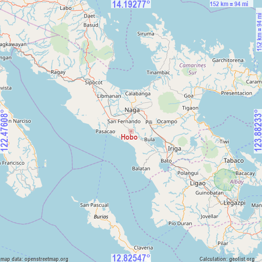
Hobo GPS coordinates[2]
13° 30' 36.36" North, 123° 10' 45.12" East
| Map corner | latitude | longitude |
|---|---|---|
| Upper-left | 14.19277°, | 122.47608° |
| Center: | 13.5101°, | 123.1792° |
| Lower-right: | 12.82547°, | 123.88233° |
| Map W x H: | 152×152 km | = 94.4×94.4mi |
| max Lat: | 20.78733° ⇑37.7% North |
| Hobo: | 13.5101° |
| min Lat: | ⇓62.3% South 4.65442° |
| min Long | Hobo | max Long |
| 117.04868° | 123.1792° | 126.58417° |
| W 56.4%⇐ | ⇒43.6% E |
Elevation
Elevation of Hobo is 24 m = 79 ft, and this is 63.9 m = 210 ft below average elevation for this country.
| Max E: |
2262 m = 7421 ft | 48.9% |
| Avg. | 87.9 m = 288 ft | |
| Hobo | 24 m = 79 ft | |
Min E: |
-2 m = -7 ft | 51.1% |
See also: Philippines elevation on elevation.city.
Geographical zone
Hobo is located in North Torrid zone (between Equator and Tropic of Cancer). Distance of this Northern Tropic circle is 1103.7 km =685.8 mi to North.| Distance of | km | miles | from Hobo |
|---|---|---|---|
| North Pole | 8504.9 | 5284.7 | to North |
| Arctic Circle | 5899 | 3665.5 | to North |
| Tropic Cancer | 1103.7 | 685.8 | to North |
| Equator | 1502.2 | 933.4 | to South |


Nearby cities:
15 places around Hobo: (largest is in red/bold)
• Antipolo
2.8 km =1.7 mi,  318°
318°
• Baliuag Nuevo
2.7 km =1.7 mi,  62°
62°
• Beberon
5.7 km =3.5 mi,  312°
312°
• Bula
11.6 km =7.2 mi,  112°
112°
• Capucnasan
10.8 km =6.7 mi,  22°
22°
• Causip
11.3 km =7 mi,  86°
86°
• Lupi
4.1 km =2.5 mi, 309°
• Milaor
9.6 km =6 mi,  358°
358°
• Minalabac
6.5 km =4 mi,  4°
4°
• Pawili
11.3 km =7 mi, 86°
• Salingogan
8.7 km =5.4 mi,  170°
170°
• San Agustin
11.6 km =7.2 mi,  52°
52°
• San Fernando
7.2 km =4.5 mi,  329°
329°
• San Gabriel
10.6 km =6.6 mi, 306°
• Tariric
8.4 km =5.2 mi,  34°
34°
Sources, notices
• [Note1] Compared only with cities in Philippines existing in our database
• [Src1] Map data: © OpenStreetMap contributors (CC-BY-SA)
• [Src2] Other city data from geonames.org with taken over terms of usage.
• [Src3] Geographical zone / Annual Mean Temperature by Robert A. Rohde @ Wikipedia
