Bulihan geodata
Bulihan (Calabarzon) is a populated place; located in Philippines in Asia/Manila (GMT+8) time zone. With population of 3,371 people, there are 2168 cities with bigger population in this country. Compared to other cities in Philippines, 65.5% of cities are located further ↓South; 70.8% of cities are located further →East and 85.2% of cities have lower elevation than Bulihan. Note1


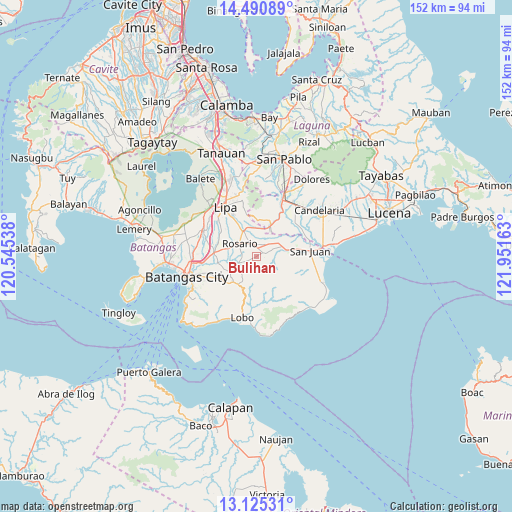
Bulihan GPS coordinates[2]
13° 48' 32.76" North, 121° 14' 54.6" East
| Map corner | latitude | longitude |
|---|---|---|
| Upper-left | 14.49089°, | 120.54538° |
| Center: | 13.8091°, | 121.2485° |
| Lower-right: | 13.12531°, | 121.95163° |
| Map W x H: | 151.8×151.8 km | = 94.3×94.3mi |
| max Lat: | 20.78733° ⇑34.5% North |
| Bulihan: | 13.8091° |
| min Lat: | ⇓65.5% South 4.65442° |
| min Long | Bulihan | max Long |
| 117.04868° | 121.2485° | 126.58417° |
| W 29.2%⇐ | ⇒70.8% E |
Elevation
Elevation of Bulihan is 141 m = 463 ft, and this is 53.1 m = 174 ft above average elevation for this country.
| Max E: |
2262 m = 7421 ft | 14.8% |
| Bulihan | 141 m 463 ft | |
| Avg. | 87.9 m = 288 ft | |
Min E: |
-2 m = -7 ft | 85.2% |
See also: Philippines elevation on elevation.city.
Geographical zone
Bulihan is located in North Torrid zone (between Equator and Tropic of Cancer). Distance of this Northern Tropic circle is 1070.5 km =665.2 mi to North.| Distance of | km | miles | from Bulihan |
|---|---|---|---|
| North Pole | 8471.6 | 5264 | to North |
| Arctic Circle | 5865.7 | 3644.8 | to North |
| Tropic Cancer | 1070.5 | 665.2 | to North |
| Equator | 1535.4 | 954.1 | to South |


Nearby cities:
15 places around Bulihan: (largest is in red/bold)
• Alupay
7.6 km =4.7 mi,  56°
56°
• Banaybanay
6.9 km =4.3 mi,  310°
310°
• Baybayin
2.7 km =1.7 mi, 60°
• Maugat West
6.9 km =4.3 mi,  32°
32°
• Padre Garcia
8.6 km =5.3 mi,  334°
334°
• Pansol
8.6 km =5.3 mi,  356°
356°
• Pinagsibaan
8.4 km =5.2 mi,  69°
69°
• Putingkahoy
8.9 km =5.5 mi, 74°
• Quilo-quilo
6.8 km =4.2 mi, 333°
• Rosario
6.2 km =3.9 mi, 310°
• San Carlos
3.8 km =2.4 mi,  348°
348°
• San Isidro
4.9 km =3 mi,  202°
202°
• San Miguel
9 km =5.6 mi,  323°
323°
• Santa Cruz
9 km =5.6 mi, 313°
• Taysan
6.5 km =4 mi,  258°
258°
Sources, notices
• [Note1] Compared only with cities in Philippines existing in our database
• [Src1] Map data: © OpenStreetMap contributors (CC-BY-SA)
• [Src2] Other city data from geonames.org with taken over terms of usage.
• [Src3] Geographical zone / Annual Mean Temperature by Robert A. Rohde @ Wikipedia
