Mników geodata
Mników (Lesser Poland) is a populated place; located in Poland in Europe/Warsaw (GMT+2) time zone. With population of 1,212 people, there are 2156 cities with bigger population in this country. Compared to other cities in Poland, 79.6% of cities are located further ↑North; 53.4% of cities are located further ←West and 69.8% of cities have lower elevation than Mników. Note1


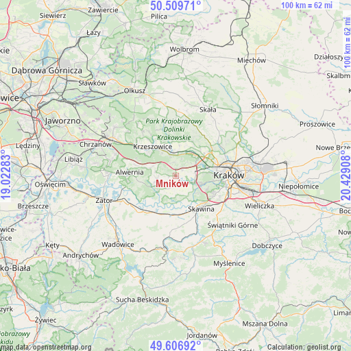
Mników GPS coordinates[2]
50° 3' 37.584" North, 19° 43' 33.42" East
| Map corner | latitude | longitude |
|---|---|---|
| Upper-left | 50.50971°, | 19.02283° |
| Center: | 50.06044°, | 19.72595° |
| Lower-right: | 49.60692°, | 20.42908° |
| Map W x H: | 100.4×100.4 km | = 62.4×62.4mi |
| max Lat: | 54.83135° ⇑79.6% North |
| Mników: | 50.06044° |
| min Lat: | ⇓20.4% South 49.21328° |
| min Long | Mników | max Long |
| 14.20249° | 19.72595° | 24.03723° |
| W 53.4%⇐ | ⇒46.6% E |
Elevation
Elevation of Mników is 229 m = 751 ft, and this is 37.6 m = 123 ft above average elevation for this country.
| Max E: |
974 m = 3196 ft | 30.2% |
| Mników | 229 m 751 ft | |
| Avg. | 191.4 m = 628 ft | |
Min E: |
-3 m = -10 ft | 69.8% |
See also: Poland elevation on elevation.city.
Geographical zone
Mników is located in North temperate zone (between Tropic of Cancer and the Arctic Circle). Distance of this North polar circle is 1835 km =1140.2 mi to North.| Distance of | km | miles | from Mników |
|---|---|---|---|
| North Pole | 4440.9 | 2759.4 | to North |
| Arctic Circle | 1835 | 1140.2 | to North |
| Tropic Cancer | 2960.3 | 1839.4 | to South |
| Equator | 5566.2 | 3458.7 | to South |


Nearby cities:
15 places around Mników: (largest is in red/bold)
• Aleksandrowice
3.7 km =2.3 mi,  48°
48°
• Balice
5.8 km =3.6 mi,  57°
57°
• Brzoskwinia
3.9 km =2.4 mi,  345°
345°
• Cholerzyn
2.7 km =1.7 mi,  92°
92°
• Czułów
1.8 km =1.1 mi,  266°
266°
• Kaszów
2.4 km =1.5 mi,  191°
191°
• Kryspinów
5.5 km =3.4 mi,  109°
109°
• Liszki
3.9 km =2.4 mi,  128°
128°
• Morawica
2.5 km =1.6 mi, 49°
• Nielepice
5.6 km =3.5 mi,  341°
341°
• Nowa Wieś Szlachecka
4.2 km =2.6 mi,  208°
208°
• Piekary
6.4 km =4 mi, 128°
• Przeginia Duchowna
6.8 km =4.2 mi,  229°
229°
• Rączna
6.4 km =4 mi,  151°
151°
• Sanka
5.8 km =3.6 mi,  279°
279°
Sources, notices
• [Note1] Compared only with cities in Poland existing in our database
• [Src1] Map data: © OpenStreetMap contributors (CC-BY-SA)
• [Src2] Other city data from geonames.org with taken over terms of usage.
• [Src3] Geographical zone / Annual Mean Temperature by Robert A. Rohde @ Wikipedia
