Milówka geodata
Milówka (Silesia) is a populated place; located in Poland in Europe/Warsaw (GMT+2) time zone. With population of 4,448 people, there are 744 cities with bigger population in this country. Compared to other cities in Poland, 97.6% of cities are located further ↑North; 58.5% of cities are located further →East and 96.2% of cities have lower elevation than Milówka. Note1


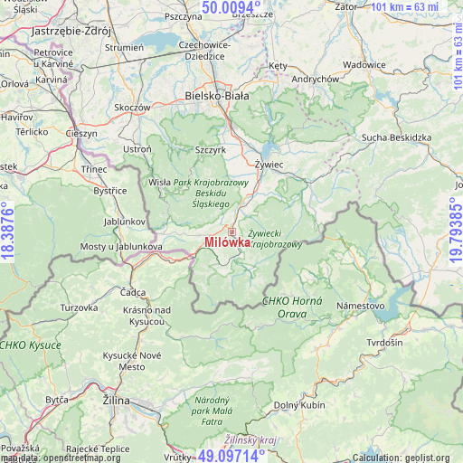
Milówka GPS coordinates[2]
49° 33' 19.44" North, 19° 5' 26.592" East
| Map corner | latitude | longitude |
|---|---|---|
| Upper-left | 50.0094°, | 18.3876° |
| Center: | 49.5554°, | 19.09072° |
| Lower-right: | 49.09714°, | 19.79385° |
| Map W x H: | 101.4×101.4 km | = 63×63mi |
| max Lat: | 54.83135° ⇑97.6% North |
| Milówka: | 49.5554° |
| min Lat: | ⇓2.4% South 49.21328° |
| min Long | Milówka | max Long |
| 14.20249° | 19.09072° | 24.03723° |
| W 41.5%⇐ | ⇒58.5% E |
Elevation
Elevation of Milówka is 448 m = 1470 ft, and this is 256.6 m = 842 ft above average elevation for this country.
| Max E: |
974 m = 3196 ft | 3.8% |
| Milówka | 448 m 1470 ft | |
| Avg. | 191.4 m = 628 ft | |
Min E: |
-3 m = -10 ft | 96.2% |
See also: Poland elevation on elevation.city.
Geographical zone
Milówka is located in North temperate zone (between Tropic of Cancer and the Arctic Circle). Distance of this North polar circle is 1891.1 km =1175.1 mi to North.| Distance of | km | miles | from Milówka |
|---|---|---|---|
| North Pole | 4497 | 2794.3 | to North |
| Arctic Circle | 1891.1 | 1175.1 | to North |
| Tropic Cancer | 2904.1 | 1804.5 | to South |
| Equator | 5510 | 3423.8 | to South |


Nearby cities:
15 places around Milówka: (largest is in red/bold)
• Bystra
10.1 km =6.3 mi,  44°
44°
• Cisiec
4.2 km =2.6 mi,  14°
14°
• Cięcina
6.3 km =3.9 mi,  34°
34°
• Kamesznica
5.1 km =3.2 mi,  281°
281°
• Koniaków
10.2 km =6.3 mi,  267°
267°
• Laliki
6.6 km =4.1 mi,  249°
249°
• Przybędza
8.8 km =5.5 mi,  16°
16°
• Radziechowy
10.5 km =6.5 mi, 16°
• Rajcza
5.4 km =3.4 mi,  162°
162°
• Rycerka Dolna
8.9 km =5.5 mi,  193°
193°
• Sól
8.3 km =5.2 mi,  205°
205°
• Ujsoły
8.8 km =5.5 mi, 157°
• Węgierska Górka
6.1 km =3.8 mi, 17°
• Zwardoń
10.1 km =6.3 mi,  235°
235°
• Żabnica
5.5 km =3.4 mi,  58°
58°
Sources, notices
• [Note1] Compared only with cities in Poland existing in our database
• [Src1] Map data: © OpenStreetMap contributors (CC-BY-SA)
• [Src2] Other city data from geonames.org with taken over terms of usage.
• [Src3] Geographical zone / Annual Mean Temperature by Robert A. Rohde @ Wikipedia
