Czernichów geodata
Czernichów (Silesia) is a populated place; located in Poland in Europe/Warsaw (GMT+2) time zone. With population of 1,021 people, there are 2430 cities with bigger population in this country. Compared to other cities in Poland, 92.9% of cities are located further ↑North; 55.8% of cities are located further →East and 89.6% of cities have lower elevation than Czernichów. Note1


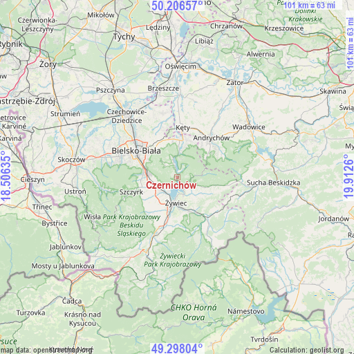
Czernichów GPS coordinates[2]
49° 45' 15.948" North, 19° 12' 34.092" East
| Map corner | latitude | longitude |
|---|---|---|
| Upper-left | 50.20657°, | 18.50635° |
| Center: | 49.75443°, | 19.20947° |
| Lower-right: | 49.29804°, | 19.9126° |
| Map W x H: | 101×101 km | = 62.8×62.8mi |
| max Lat: | 54.83135° ⇑92.9% North |
| Czernichów: | 49.75443° |
| min Lat: | ⇓7.1% South 49.21328° |
| min Long | Czernichów | max Long |
| 14.20249° | 19.20947° | 24.03723° |
| W 44.2%⇐ | ⇒55.8% E |
Elevation
Elevation of Czernichów is 322 m = 1056 ft, and this is 130.6 m = 428 ft above average elevation for this country.
| Max E: |
974 m = 3196 ft | 10.4% |
| Czernichów | 322 m 1056 ft | |
| Avg. | 191.4 m = 628 ft | |
Min E: |
-3 m = -10 ft | 89.6% |
See also: Poland elevation on elevation.city.
Geographical zone
Czernichów is located in North temperate zone (between Tropic of Cancer and the Arctic Circle). Distance of this North polar circle is 1869 km =1161.3 mi to North.| Distance of | km | miles | from Czernichów |
|---|---|---|---|
| North Pole | 4474.9 | 2780.6 | to North |
| Arctic Circle | 1869 | 1161.3 | to North |
| Tropic Cancer | 2926.3 | 1818.3 | to South |
| Equator | 5532.2 | 3437.5 | to South |


Nearby cities:
15 places around Czernichów: (largest is in red/bold)
• Buczkowice
10.5 km =6.5 mi,  254°
254°
• Bystra
10.8 km =6.7 mi,  273°
273°
• Gilowice
8.6 km =5.3 mi,  122°
122°
• Godziszka
10.7 km =6.6 mi,  244°
244°
• Międzybrodzie Bialskie
3.8 km =2.4 mi,  346°
346°
• Pietrzykowice
7.4 km =4.6 mi,  208°
208°
• Porąbka
7 km =4.3 mi,  5°
5°
• Rybarzowice
8.2 km =5.1 mi, 250°
• Targanice
10 km =6.2 mi,  55°
55°
• Tresna
1.9 km =1.2 mi,  183°
183°
• Wilkowice
8.7 km =5.4 mi,  276°
276°
• Zarzecze
4.6 km =2.9 mi, 212°
• Łodygowice
5.7 km =3.5 mi, 241°
• Łękawica
5.4 km =3.4 mi,  132°
132°
• Żywiec
7.8 km =4.8 mi,  189°
189°
Sources, notices
• [Note1] Compared only with cities in Poland existing in our database
• [Src1] Map data: © OpenStreetMap contributors (CC-BY-SA)
• [Src2] Other city data from geonames.org with taken over terms of usage.
• [Src3] Geographical zone / Annual Mean Temperature by Robert A. Rohde @ Wikipedia
