Jaworowa geodata
Jaworowa (Mazovia) is a populated place; located in Poland in Europe/Warsaw (GMT+2) time zone. With population of 750 people, there are 2953 cities with bigger population in this country. Compared to other cities in Poland, 68.8% of cities are located further ↓South; 71.8% of cities are located further ←West and 78.8% of cities have higher elevation than Jaworowa. Note1


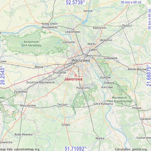
Jaworowa GPS coordinates[2]
52° 8' 40.2" North, 20° 57' 27.432" East
| Map corner | latitude | longitude |
|---|---|---|
| Upper-left | 52.5739°, | 20.2545° |
| Center: | 52.1445°, | 20.95762° |
| Lower-right: | 51.71092°, | 21.66075° |
| Map W x H: | 96×96 km | = 59.7×59.7mi |
| max Lat: | 54.83135° ⇑31.2% North |
| Jaworowa: | 52.1445° |
| min Lat: | ⇓68.8% South 49.21328° |
| min Long | Jaworowa | max Long |
| 14.20249° | 20.95762° | 24.03723° |
| W 71.8%⇐ | ⇒28.2% E |
Elevation
Elevation of Jaworowa is 102 m = 335 ft, and this is 89.4 m = 293 ft below average elevation for this country.
| Max E: |
974 m = 3196 ft | 78.8% |
| Avg. | 191.4 m = 628 ft | |
| Jaworowa | 102 m = 335 ft | |
Min E: |
-3 m = -10 ft | 21.2% |
See also: Poland elevation on elevation.city.
Geographical zone
Jaworowa is located in North temperate zone (between Tropic of Cancer and the Arctic Circle). Distance of this North polar circle is 1603.2 km =996.2 mi to North.| Distance of | km | miles | from Jaworowa |
|---|---|---|---|
| North Pole | 4209.1 | 2615.4 | to North |
| Arctic Circle | 1603.2 | 996.2 | to North |
| Tropic Cancer | 3192 | 1983.4 | to South |
| Equator | 5797.9 | 3602.6 | to South |


Nearby cities:
15 places around Jaworowa: (largest is in red/bold)
• Józefosław
7.8 km =4.8 mi,  128°
128°
• Kabaty
8.6 km =5.3 mi,  100°
100°
• Lesznowola
6.2 km =3.9 mi,  194°
194°
• Michałowice
6.2 km =3.9 mi,  302°
302°
• Mokotów
7.6 km =4.7 mi,  44°
44°
• Mysiadło
6.3 km =3.9 mi,  138°
138°
• Nowa Iwiczna
6.7 km =4.2 mi,  151°
151°
• Nowe Grocholice
3.6 km =2.2 mi, 297°
• Piaseczno
8.4 km =5.2 mi, 147°
• Raszyn
2.7 km =1.7 mi, 298°
• Reguły
7.3 km =4.5 mi, 298°
• Rybie
1.7 km =1.1 mi, 301°
• Ursus
7.5 km =4.7 mi,  318°
318°
• Ursynów
6.4 km =4 mi,  83°
83°
• Włochy
4 km =2.5 mi,  348°
348°
Sources, notices
• [Note1] Compared only with cities in Poland existing in our database
• [Src1] Map data: © OpenStreetMap contributors (CC-BY-SA)
• [Src2] Other city data from geonames.org with taken over terms of usage.
• [Src3] Geographical zone / Annual Mean Temperature by Robert A. Rohde @ Wikipedia
