Włochy geodata
Włochy (Mazovia) is a populated place; located in Poland in Europe/Warsaw (GMT+2) time zone. With population of 36,276 people, there are 145 cities with bigger population in this country. Compared to other cities in Poland, 69.6% of cities are located further ↓South; 71.5% of cities are located further ←West and 75.8% of cities have higher elevation than Włochy. Note1


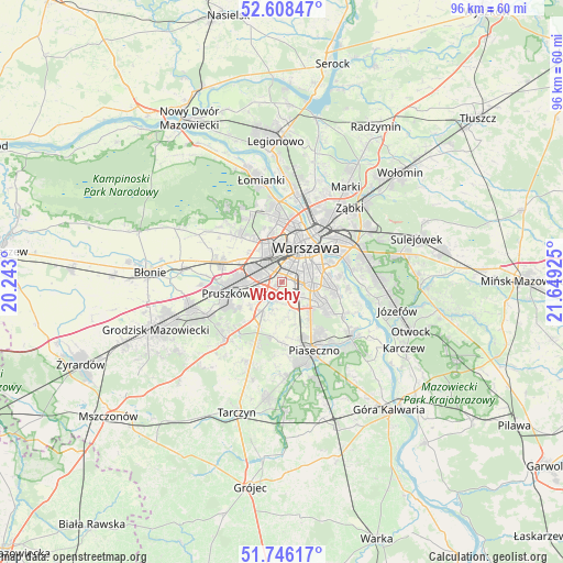
Włochy GPS coordinates[2]
52° 10' 45.876" North, 20° 56' 46.032" East
| Map corner | latitude | longitude |
|---|---|---|
| Upper-left | 52.60847°, | 20.243° |
| Center: | 52.17941°, | 20.94612° |
| Lower-right: | 51.74617°, | 21.64925° |
| Map W x H: | 95.9×95.9 km | = 59.6×59.6mi |
| max Lat: | 54.83135° ⇑30.4% North |
| Włochy: | 52.17941° |
| min Lat: | ⇓69.6% South 49.21328° |
| min Long | Włochy | max Long |
| 14.20249° | 20.94612° | 24.03723° |
| W 71.5%⇐ | ⇒28.5% E |
Elevation
Elevation of Włochy is 109 m = 358 ft, and this is 82.4 m = 270 ft below average elevation for this country.
| Max E: |
974 m = 3196 ft | 75.8% |
| Avg. | 191.4 m = 628 ft | |
| Włochy | 109 m = 358 ft | |
Min E: |
-3 m = -10 ft | 24.2% |
See also: Poland elevation on elevation.city.
Geographical zone
Włochy is located in North temperate zone (between Tropic of Cancer and the Arctic Circle). Distance of this North polar circle is 1599.4 km =993.8 mi to North.| Distance of | km | miles | from Włochy |
|---|---|---|---|
| North Pole | 4205.3 | 2613.1 | to North |
| Arctic Circle | 1599.4 | 993.8 | to North |
| Tropic Cancer | 3195.9 | 1985.8 | to South |
| Equator | 5801.8 | 3605.1 | to South |


Nearby cities:
15 places around Włochy: (largest is in red/bold)
• Bemowo
8.7 km =5.4 mi,  342°
342°
• Jaworowa
4 km =2.5 mi,  168°
168°
• Michałowice
4.5 km =2.8 mi,  262°
262°
• Mokotów
6.2 km =3.9 mi,  75°
75°
• Nowe Grocholice
3.3 km =2.1 mi,  226°
226°
• Ochota
5.3 km =3.3 mi,  30°
30°
• Piastów
7.3 km =4.5 mi,  274°
274°
• Raszyn
3.1 km =1.9 mi,  211°
211°
• Reguły
5.6 km =3.5 mi, 265°
• Rybie
3.1 km =1.9 mi,  192°
192°
• Ursus
4.6 km =2.9 mi,  292°
292°
• Ursynów
7.8 km =4.8 mi,  114°
114°
• Warsaw
7.2 km =4.5 mi,  38°
38°
• Wola
7.3 km =4.5 mi,  23°
23°
• Śródmieście
7.3 km =4.5 mi, 40°
Sources, notices
• [Note1] Compared only with cities in Poland existing in our database
• [Src1] Map data: © OpenStreetMap contributors (CC-BY-SA)
• [Src2] Other city data from geonames.org with taken over terms of usage.
• [Src3] Geographical zone / Annual Mean Temperature by Robert A. Rohde @ Wikipedia
