Ḩattā geodata
Ḩattā is a populated place; located in Palestinian Territory in Asia/Hebron (GMT+3) time zone. With population of 878 people, there are 340 cities with bigger population in this country. Compared to other cities in Palestinian Territory, 79.1% of cities are located further ↑North; 85.2% of cities are located further →East and 52.2% of cities have higher elevation than Ḩattā. Note1


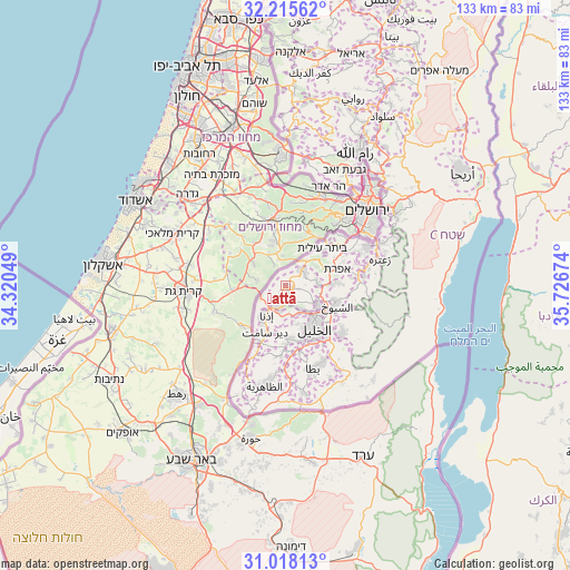
Ḩattā GPS coordinates[2]
31° 37' 7.68" North, 35° 1' 24.996" East
| Map corner | latitude | longitude |
|---|---|---|
| Upper-left | 32.21562°, | 34.32049° |
| Center: | 31.6188°, | 35.02361° |
| Lower-right: | 31.01813°, | 35.72674° |
| Map W x H: | 133.1×133.1 km | = 82.7×82.7mi |
| max Lat: | 32.54346° ⇑79.1% North |
| Ḩattā: | 31.6188° |
| min Lat: | ⇓20.9% South 31.25997° |
| min Long | Ḩattā | max Long |
| 34.24357° | 35.02361° | 35.53898° |
| W 14.8%⇐ | ⇒85.2% E |
Elevation
Elevation of Ḩattā is 468 m = 1535 ft, and this is 5.3 m = 17 ft below average elevation for this country.
| Max E: |
999 m = 3278 ft | 52.2% |
| Avg. | 473.3 m = 1553 ft | |
| Ḩattā | 468 m = 1535 ft | |
Min E: |
-269 m = -883 ft | 47.8% |
See also: Palestinian Territory elevation on elevation.city.
Geographical zone
Ḩattā is located in North temperate zone (between Tropic of Cancer and the Arctic Circle). Distance of this Northern Tropic circle is 909.8 km =565.3 mi to South.| Distance of | km | miles | from Ḩattā |
|---|---|---|---|
| North Pole | 6491.4 | 4033.6 | to North |
| Arctic Circle | 3885.5 | 2414.3 | to North |
| Tropic Cancer | 909.8 | 565.3 | to South |
| Equator | 3515.7 | 2184.6 | to South |


Nearby cities:
15 places around Ḩattā: (largest is in red/bold)
• Bayt Kāḩil
6.7 km =4.2 mi,  144°
144°
• Bayt Maqdum
10.5 km =6.5 mi,  207°
207°
• Bayt Ūlā
2.6 km =1.6 mi,  167°
167°
• Bayt Ūmmar
7.7 km =4.8 mi,  86°
86°
• Bayt ‘Īnūn
11.7 km =7.3 mi,  124°
124°
• Idhnā
8.1 km =5 mi, 214°
• Khārās
1.8 km =1.1 mi,  104°
104°
• Naḩḩālīn
11.8 km =7.3 mi,  51°
51°
• Nūbā
1.5 km =0.9 mi, 136°
• Shuyūkh al ‘Arrūb
11.4 km =7.1 mi, 90°
• Taffūḩ
9.3 km =5.8 mi,  164°
164°
• Tarqūmyā
4.9 km =3 mi,  192°
192°
• al-Kum
11.4 km =7.1 mi, 211°
• Şūrīf
5.2 km =3.2 mi, 47°
• Ḩalḩūl
8.6 km =5.3 mi, 120°
Sources, notices
• [Note1] Compared only with cities in Palestinian Territory existing in our database
• [Src1] Map data: © OpenStreetMap contributors (CC-BY-SA)
• [Src2] Other city data from geonames.org with taken over terms of usage.
• [Src3] Geographical zone / Annual Mean Temperature by Robert A. Rohde @ Wikipedia
