Aş Şūrrah geodata
Aş Şūrrah is a populated place; located in Palestinian Territory in Asia/Hebron (GMT+3) time zone. With population of 1,896 people, there are 253 cities with bigger population in this country. Compared to other cities in Palestinian Territory, 88.8% of cities are located further ↑North; 89.1% of cities are located further →East and 91.6% of cities have lower elevation than Aş Şūrrah. Note1


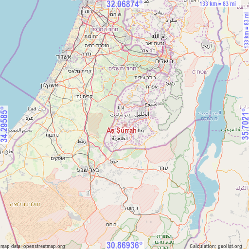
Aş Şūrrah GPS coordinates[2]
31° 28' 15.492" North, 34° 59' 56.292" East
| Map corner | latitude | longitude |
|---|---|---|
| Upper-left | 32.06874°, | 34.29585° |
| Center: | 31.47097°, | 34.99897° |
| Lower-right: | 30.86936°, | 35.7021° |
| Map W x H: | 133.4×133.4 km | = 82.9×82.9mi |
| max Lat: | 32.54346° ⇑88.8% North |
| Aş Şūrrah: | 31.47097° |
| min Lat: | ⇓11.2% South 31.25997° |
| min Long | Aş Şūrrah | max Long |
| 34.24357° | 34.99897° | 35.53898° |
| W 10.9%⇐ | ⇒89.1% E |
Elevation
Elevation of Aş Şūrrah is 829 m = 2720 ft, and this is 355.7 m = 1167 ft above average elevation for this country.
| Max E: |
999 m = 3278 ft | 8.4% |
| Aş Şūrrah | 829 m 2720 ft | |
| Avg. | 473.3 m = 1553 ft | |
Min E: |
-269 m = -883 ft | 91.6% |
See also: Palestinian Territory elevation on elevation.city.
Geographical zone
Aş Şūrrah is located in North temperate zone (between Tropic of Cancer and the Arctic Circle). Distance of this Northern Tropic circle is 893.3 km =555.1 mi to South.| Distance of | km | miles | from Aş Şūrrah |
|---|---|---|---|
| North Pole | 6507.8 | 4043.8 | to North |
| Arctic Circle | 3901.9 | 2424.5 | to North |
| Tropic Cancer | 893.3 | 555.1 | to South |
| Equator | 3499.2 | 2174.3 | to South |


Nearby cities:
15 places around Aş Şūrrah: (largest is in red/bold)
• Al Majd
4.7 km =2.9 mi,  283°
283°
• Bayt ‘Amrah
5.3 km =3.3 mi,  115°
115°
• Dayr Sāmit
6 km =3.7 mi,  337°
337°
• Dayr al ‘Asal al Fawqā
5.8 km =3.6 mi,  267°
267°
• Dayr al ‘Asal at Taḩtā
5.2 km =3.2 mi, 272°
• Dūrā
5 km =3.1 mi,  35°
35°
• Imrīsh
0.9 km =0.6 mi,  104°
104°
• Karmah
3.4 km =2.1 mi,  128°
128°
• Khursā
2.2 km =1.4 mi,  54°
54°
• Kurzah
3.4 km =2.1 mi,  178°
178°
• Rābūd
3.9 km =2.4 mi,  155°
155°
• Sikkah
5.8 km =3.6 mi,  293°
293°
• Wādī ash Shājinah
3.1 km =1.9 mi,  90°
90°
• Ţarrāmah
3.4 km =2.1 mi,  71°
71°
• Ḩadb al ‘Alqah
1.8 km =1.1 mi,  192°
192°
Sources, notices
• [Note1] Compared only with cities in Palestinian Territory existing in our database
• [Src1] Map data: © OpenStreetMap contributors (CC-BY-SA)
• [Src2] Other city data from geonames.org with taken over terms of usage.
• [Src3] Geographical zone / Annual Mean Temperature by Robert A. Rohde @ Wikipedia
