Qalqīlyah geodata
Qalqīlyah (West Bank) is a populated place; located in Palestinian Territory in Asia/Hebron (GMT+3) time zone. With population of 43,212 people, there are 10 cities with bigger population in this country. Compared to other cities in Palestinian Territory, 68.2% of cities are located further ↓South; 91.6% of cities are located further →East and 90.8% of cities have higher elevation than Qalqīlyah. Note1


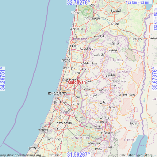
Qalqīlyah GPS coordinates[2]
32° 11' 22.776" North, 34° 58' 14.268" East
| Map corner | latitude | longitude |
|---|---|---|
| Upper-left | 32.78276°, | 34.26751° |
| Center: | 32.18966°, | 34.97063° |
| Lower-right: | 31.59267°, | 35.67376° |
| Map W x H: | 132.3×132.3 km | = 82.2×82.2mi |
| max Lat: | 32.54346° ⇑31.8% North |
| Qalqīlyah: | 32.18966° |
| min Lat: | ⇓68.2% South 31.25997° |
| min Long | Qalqīlyah | max Long |
| 34.24357° | 34.97063° | 35.53898° |
| W 8.4%⇐ | ⇒91.6% E |
Elevation
Elevation of Qalqīlyah is 87 m = 285 ft, and this is 386.3 m = 1267 ft below average elevation for this country.
| Max E: |
999 m = 3278 ft | 90.8% |
| Avg. | 473.3 m = 1553 ft | |
| Qalqīlyah | 87 m = 285 ft | |
Min E: |
-269 m = -883 ft | 9.2% |
See also: Qalqīlyah elevation on elevation.city.
Geographical zone
Qalqīlyah is located in North temperate zone (between Tropic of Cancer and the Arctic Circle). Distance of this Northern Tropic circle is 973.2 km =604.7 mi to South.| Distance of | km | miles | from Qalqīlyah |
|---|---|---|---|
| North Pole | 6427.9 | 3994.1 | to North |
| Arctic Circle | 3822 | 2374.9 | to North |
| Tropic Cancer | 973.2 | 604.7 | to South |
| Equator | 3579.2 | 2224 | to South |


Nearby cities:
15 places around Qalqīlyah: (largest is in red/bold)
• An Nabī Ilyās
4.5 km =2.8 mi,  96°
96°
• Azun Atme
8.9 km =5.5 mi,  148°
148°
• Bayt Amīn
8 km =5 mi,  143°
143°
• Falāmyah
6.3 km =3.9 mi,  51°
51°
• Jayyūs
6.1 km =3.8 mi,  77°
77°
• Kafr Jammāl
7.9 km =4.9 mi,  59°
59°
• Kafr Thulth
8.2 km =5.1 mi,  119°
119°
• Kafr Zībād
10.3 km =6.4 mi,  67°
67°
• Kafr Şūr
10.6 km =6.6 mi, 55°
• Oranit
6.7 km =4.2 mi,  163°
163°
• Sannīryā
9.8 km =6.1 mi,  133°
133°
• Ḩablah
2.8 km =1.7 mi,  166°
166°
• ‘Aslah
6.4 km =4 mi,  106°
106°
• ‘Azzūn
8.3 km =5.2 mi, 101°
• ‘Izbat Salmān
5.9 km =3.7 mi, 153°
Sources, notices
• [Note1] Compared only with cities in Palestinian Territory existing in our database
• [Src1] Map data: © OpenStreetMap contributors (CC-BY-SA)
• [Src2] Other city data from geonames.org with taken over terms of usage.
• [Src3] Geographical zone / Annual Mean Temperature by Robert A. Rohde @ Wikipedia
