Battīr geodata
Battīr (West Bank) is a populated place; located in Palestinian Territory in Asia/Hebron (GMT+3) time zone. With population of 4,092 people, there are 135 cities with bigger population in this country. Compared to other cities in Palestinian Territory, 72.5% of cities are located further ↑North; 57.8% of cities are located further →East and 87.3% of cities have lower elevation than Battīr. Note1


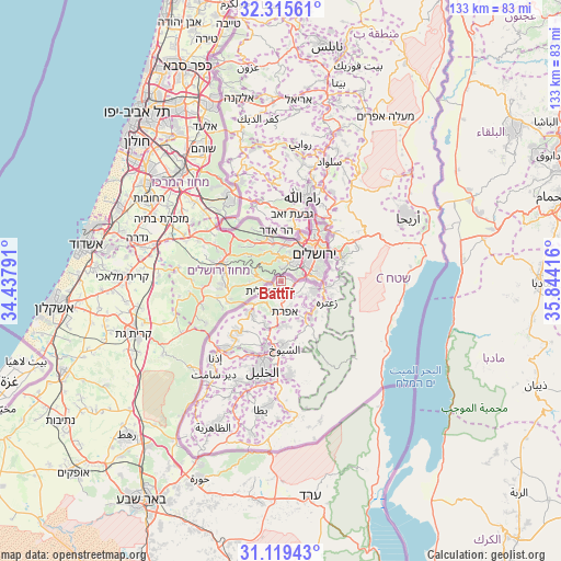
Battīr GPS coordinates[2]
31° 43' 10.02" North, 35° 8' 27.708" East
| Map corner | latitude | longitude |
|---|---|---|
| Upper-left | 32.31561°, | 34.43791° |
| Center: | 31.71945°, | 35.14103° |
| Lower-right: | 31.11943°, | 35.84416° |
| Map W x H: | 133×133 km | = 82.6×82.6mi |
| max Lat: | 32.54346° ⇑72.5% North |
| Battīr: | 31.71945° |
| min Lat: | ⇓27.5% South 31.25997° |
| min Long | Battīr | max Long |
| 34.24357° | 35.14103° | 35.53898° |
| W 42.2%⇐ | ⇒57.8% E |
Elevation
Elevation of Battīr is 799 m = 2621 ft, and this is 325.7 m = 1069 ft above average elevation for this country.
| Max E: |
999 m = 3278 ft | 12.7% |
| Battīr | 799 m 2621 ft | |
| Avg. | 473.3 m = 1553 ft | |
Min E: |
-269 m = -883 ft | 87.3% |
See also: Palestinian Territory elevation on elevation.city.
Geographical zone
Battīr is located in North temperate zone (between Tropic of Cancer and the Arctic Circle). Distance of this Northern Tropic circle is 921 km =572.3 mi to South.| Distance of | km | miles | from Battīr |
|---|---|---|---|
| North Pole | 6480.2 | 4026.6 | to North |
| Arctic Circle | 3874.3 | 2407.4 | to North |
| Tropic Cancer | 921 | 572.3 | to South |
| Equator | 3526.9 | 2191.5 | to South |


Nearby cities:
15 places around Battīr: (largest is in red/bold)
• Ad Dawḩah
4.3 km =2.7 mi,  120°
120°
• Al Khaḑir
3.7 km =2.3 mi,  139°
139°
• Al Ma‘şarah
8 km =5 mi,  153°
153°
• Arţās
5.5 km =3.4 mi,  127°
127°
• Bayt Jālā
4.5 km =2.8 mi,  95°
95°
• Bethlehem
6.2 km =3.9 mi,  105°
105°
• Bi’r ‘Awnah
3.5 km =2.2 mi,  89°
89°
• Jūrat ash Sham‘ah
8.1 km =5 mi,  160°
160°
• Khallat al Lūzah
7.7 km =4.8 mi, 131°
• Khallat Ḩamāmah
4.9 km =3 mi, 87°
• Naḩḩālīn
4.2 km =2.6 mi,  206°
206°
• Wādī Fūkīn
3.8 km =2.4 mi,  248°
248°
• Wādī Raḩḩāl
6.5 km =4 mi, 157°
• Wādī an Nīş
7.5 km =4.7 mi,  165°
165°
• Ḩūsān
1.3 km =0.8 mi, 207°
Sources, notices
• [Note1] Compared only with cities in Palestinian Territory existing in our database
• [Src1] Map data: © OpenStreetMap contributors (CC-BY-SA)
• [Src2] Other city data from geonames.org with taken over terms of usage.
• [Src3] Geographical zone / Annual Mean Temperature by Robert A. Rohde @ Wikipedia
