Al Hāshimīyah geodata
Al Hāshimīyah (West Bank) is a populated place; located in Palestinian Territory in Asia/Hebron (GMT+3) time zone. With population of 1,038 people, there are 323 cities with bigger population in this country. Compared to other cities in Palestinian Territory, 95.7% of cities are located further ↓South; 67.2% of cities are located further ←West and 66.4% of cities have higher elevation than Al Hāshimīyah. Note1


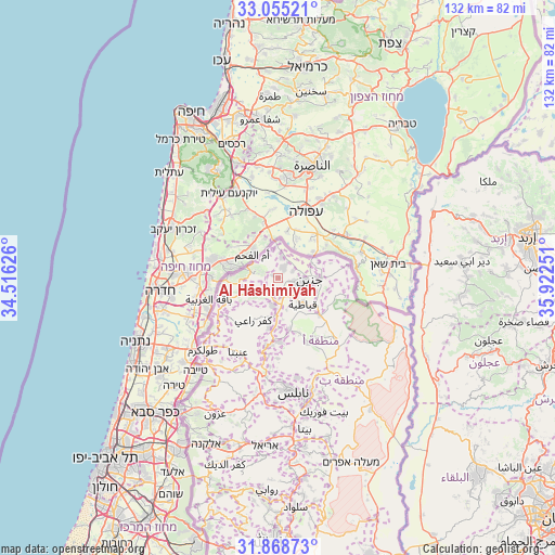
Al Hāshimīyah GPS coordinates[2]
32° 27' 50.112" North, 35° 13' 9.768" East
| Map corner | latitude | longitude |
|---|---|---|
| Upper-left | 33.05521°, | 34.51626° |
| Center: | 32.46392°, | 35.21938° |
| Lower-right: | 31.86873°, | 35.92251° |
| Map W x H: | 131.9×131.9 km | = 82×82mi |
| max Lat: | 32.54346° ⇑4.3% North |
| Al Hāshimīyah: | 32.46392° |
| min Lat: | ⇓95.7% South 31.25997° |
| min Long | Al Hāshimīyah | max Long |
| 34.24357° | 35.21938° | 35.53898° |
| W 67.2%⇐ | ⇒32.8% E |
Elevation
Elevation of Al Hāshimīyah is 360 m = 1181 ft, and this is 113.3 m = 372 ft below average elevation for this country.
| Max E: |
999 m = 3278 ft | 66.4% |
| Avg. | 473.3 m = 1553 ft | |
| Al Hāshimīyah | 360 m = 1181 ft | |
Min E: |
-269 m = -883 ft | 33.6% |
See also: Palestinian Territory elevation on elevation.city.
Geographical zone
Al Hāshimīyah is located in North temperate zone (between Tropic of Cancer and the Arctic Circle). Distance of this Northern Tropic circle is 1003.7 km =623.7 mi to South.| Distance of | km | miles | from Al Hāshimīyah |
|---|---|---|---|
| North Pole | 6397.4 | 3975.2 | to North |
| Arctic Circle | 3791.5 | 2355.9 | to North |
| Tropic Cancer | 1003.7 | 623.7 | to South |
| Equator | 3609.6 | 2242.9 | to South |


Nearby cities:
15 places around Al Hāshimīyah: (largest is in red/bold)
• Al Yāmūn
2.6 km =1.6 mi,  22°
22°
• Al ‘Araqa
1.9 km =1.2 mi,  292°
292°
• Ash Shuhadā’
6.2 km =3.9 mi,  128°
128°
• Aţ Ţaybah
6.5 km =4 mi,  330°
330°
• Birqīn
4 km =2.5 mi,  104°
104°
• Bīr al Bāshā
5 km =3.1 mi,  168°
168°
• Kafr Dān
3.7 km =2.3 mi,  63°
63°
• Kafr Qūd
1.1 km =0.7 mi,  140°
140°
• Kufayrit
2.8 km =1.7 mi,  216°
216°
• Nazlat ash Shaykh Zayd
4.2 km =2.6 mi,  267°
267°
• Sīlat al Ḩārithīyah
5 km =3.1 mi,  8°
8°
• Ti‘innik
6.2 km =3.9 mi,  0°
0°
• Ya‘bad
5.2 km =3.2 mi,  247°
247°
• Ţūrah al Gharbīyah
6.3 km =3.9 mi, 274°
• ‘Anīn
6.6 km =4.1 mi,  311°
311°
Sources, notices
• [Note1] Compared only with cities in Palestinian Territory existing in our database
• [Src1] Map data: © OpenStreetMap contributors (CC-BY-SA)
• [Src2] Other city data from geonames.org with taken over terms of usage.
• [Src3] Geographical zone / Annual Mean Temperature by Robert A. Rohde @ Wikipedia
