Al ‘Ayzarīyah geodata
Al ‘Ayzarīyah (West Bank) is a populated place; located in Palestinian Territory in Asia/Hebron (GMT+3) time zone. With population of 17,455 people, there are 34 cities with bigger population in this country. Compared to other cities in Palestinian Territory, 71% of cities are located further ↑North; 81.2% of cities are located further ←West and 61.3% of cities have lower elevation than Al ‘Ayzarīyah. Note1


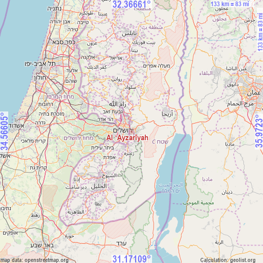
Al ‘Ayzarīyah GPS coordinates[2]
31° 46' 14.808" North, 35° 16' 9.012" East
| Map corner | latitude | longitude |
|---|---|---|
| Upper-left | 32.36661°, | 34.56605° |
| Center: | 31.77078°, | 35.26917° |
| Lower-right: | 31.17109°, | 35.9723° |
| Map W x H: | 132.9×132.9 km | = 82.6×82.6mi |
| max Lat: | 32.54346° ⇑71% North |
| Al ‘Ayzarīyah: | 31.77078° |
| min Lat: | ⇓29% South 31.25997° |
| min Long | Al ‘Ayzarīya | max Long |
| 34.24357° | 35.26917° | 35.53898° |
| W 81.2%⇐ | ⇒18.8% E |
Elevation
Elevation of Al ‘Ayzarīyah is 566 m = 1857 ft, and this is 92.7 m = 304 ft above average elevation for this country.
| Max E: |
999 m = 3278 ft | 38.7% |
| Al ‘Ayzarīyah | 566 m 1857 ft | |
| Avg. | 473.3 m = 1553 ft | |
Min E: |
-269 m = -883 ft | 61.3% |
See also: Palestinian Territory elevation on elevation.city.
Geographical zone
Al ‘Ayzarīyah is located in North temperate zone (between Tropic of Cancer and the Arctic Circle). Distance of this Northern Tropic circle is 926.7 km =575.8 mi to South.| Distance of | km | miles | from Al ‘Ayzarīyah |
|---|---|---|---|
| North Pole | 6474.5 | 4023.1 | to North |
| Arctic Circle | 3868.6 | 2403.8 | to North |
| Tropic Cancer | 926.7 | 575.8 | to South |
| Equator | 3532.6 | 2195.1 | to South |


Nearby cities:
15 places around Al ‘Ayzarīyah: (largest is in red/bold)
• Abū Dīs
1.2 km =0.7 mi,  216°
216°
• Al Ka‘ābinah (Tajammu‘ Badawī)
6.9 km =4.3 mi,  53°
53°
• Al ‘Ubaydīyah
6.3 km =3.9 mi,  161°
161°
• Ar Rām wa Ḑāḩiyat al Barīd
9.4 km =5.8 mi,  339°
339°
• Ash Shaykh Sa‘d
3.9 km =2.4 mi,  196°
196°
• Az Za‘ayyim
2 km =1.2 mi,  348°
348°
• Bayt Sāḩūr
8.8 km =5.5 mi,  207°
207°
• Bethlehem
9.6 km =6 mi, 220°
• East Jerusalem
3.6 km =2.2 mi,  292°
292°
• Khallat an Nu‘mān
6.4 km =4 mi, 203°
• Khallat Ḩamāmah
9.1 km =5.7 mi,  232°
232°
• Old City
3.4 km =2.1 mi,  281°
281°
• Ḩizmā
7 km =4.3 mi,  355°
355°
• ‘Anātā
4.4 km =2.7 mi, 347°
• ‘Arab al Jahālīn
2 km =1.2 mi,  130°
130°
Sources, notices
• [Note1] Compared only with cities in Palestinian Territory existing in our database
• [Src1] Map data: © OpenStreetMap contributors (CC-BY-SA)
• [Src2] Other city data from geonames.org with taken over terms of usage.
• [Src3] Geographical zone / Annual Mean Temperature by Robert A. Rohde @ Wikipedia
