Lajes geodata
Lajes (Azores) is a populated place; located in Portugal in Atlantic/Azores (GMT+0) time zone. With population of 3,744 people, there are 547 cities with bigger population in this country. Compared to other cities in Portugal, 71% of cities are located further ↑North; 96.8% of cities are located further →East and 63.6% of cities have higher elevation than Lajes. Note1


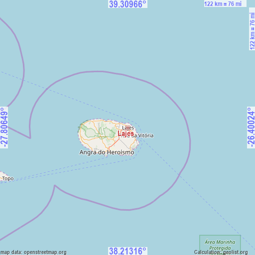
Lajes GPS coordinates[2]
38° 45' 48.672" North, 27° 6' 12.096" West
| Map corner | latitude | longitude |
|---|---|---|
| Upper-left | 39.30966°, | -27.80649° |
| Center: | 38.76352°, | -27.10336° |
| Lower-right: | 38.21316°, | -26.40024° |
| Map W x H: | 121.9×121.9 km | = 75.7×75.7mi |
| max Lat: | 42.11337° ⇑71% North |
| Lajes: | 38.76352° |
| min Lat: | ⇓29% South 32.6448° |
| min Long | Lajes | max Long |
| -31.17847° | -27.10336° | -6.27308° |
| W 3.2%⇐ | ⇒96.8% E |
Elevation
Elevation of Lajes is 67 m = 220 ft, and this is 110 m = 361 ft below average elevation for this country.
| Max E: |
1008 m = 3307 ft | 63.6% |
| Avg. | 177 m = 581 ft | |
| Lajes | 67 m = 220 ft | |
Min E: |
-128 m = -420 ft | 36.4% |
See also: Portugal elevation on elevation.city.
Geographical zone
Lajes is located in North temperate zone (between Tropic of Cancer and the Arctic Circle). Distance of this Northern Tropic circle is 1704.2 km =1058.9 mi to South.| Distance of | km | miles | from Lajes |
|---|---|---|---|
| North Pole | 5697 | 3540 | to North |
| Arctic Circle | 3091.1 | 1920.7 | to North |
| Tropic Cancer | 1704.2 | 1058.9 | to South |
| Equator | 4310.1 | 2678.2 | to South |


Nearby cities:
15 places around Lajes: (largest is in red/bold)
• Angra do Heroísmo
15.6 km =9.7 mi,  219°
219°
• Biscoitos
12.9 km =8 mi,  279°
279°
• Cabo da Praia
7.5 km =4.7 mi,  146°
146°
• Feteira
12.8 km =8 mi,  198°
198°
• Fonte Bastardo
8.2 km =5.1 mi,  165°
165°
• Porto Judeu
12.9 km =8 mi,  186°
186°
• Porto Martins
9.9 km =6.2 mi,  156°
156°
• Praia da Vitória
4.6 km =2.9 mi,  136°
136°
• Ribeira Seca
78.5 km =48.8 mi,  256°
256°
• Ribeirinha
13.1 km =8.1 mi,  210°
210°
• Santa Bárbara
21.8 km =13.5 mi,  249°
249°
• Santo Antão
65 km =40.4 mi, 248°
• São Bartolomeu
19.2 km =11.9 mi,  239°
239°
• São Mateus
18.7 km =11.6 mi,  230°
230°
• São Sebastião
10.9 km =6.8 mi, 173°
Sources, notices
• [Note1] Compared only with cities in Portugal existing in our database
• [Src1] Map data: © OpenStreetMap contributors (CC-BY-SA)
• [Src2] Other city data from geonames.org with taken over terms of usage.
• [Src3] Geographical zone / Annual Mean Temperature by Robert A. Rohde @ Wikipedia
