Fajã de Baixo geodata
Fajã de Baixo (Azores) is a populated place; located in Portugal in Atlantic/Azores (GMT+0) time zone. With population of 4,915 people, there are 434 cities with bigger population in this country. Compared to other cities in Portugal, 87.3% of cities are located further ↑North; 95.5% of cities are located further →East and 76.9% of cities have higher elevation than Fajã de Baixo. Note1
Administrative division(s):
- Level 1: Azores
- Level 2: Ponta Delgada
- Level 3: Ponta Delgada (São Pedro)


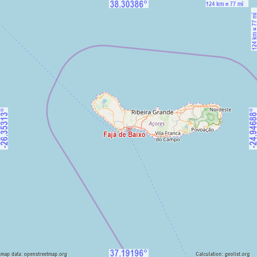
Fajã de Baixo GPS coordinates[2]
37° 45' 0" North, 25° 39' 0" West
| Map corner | latitude | longitude |
|---|---|---|
| Upper-left | 38.30386°, | -26.35313° |
| Center: | 37.75°, | -25.65° |
| Lower-right: | 37.19196°, | -24.94688° |
| Map W x H: | 123.6×123.6 km | = 76.8×76.8mi |
| max Lat: | 42.11337° ⇑87.3% North |
| Fajã de Baixo: | 37.75° |
| min Lat: | ⇓12.7% South 32.6448° |
| min Long | Fajã de Baixo | max Long |
| -31.17847° | -25.65° | -6.27308° |
| W 4.5%⇐ | ⇒95.5% E |
Elevation
Elevation of Fajã de Baixo is 37 m = 121 ft, and this is 140 m = 459 ft below average elevation for this country.
| Max E: |
1008 m = 3307 ft | 76.9% |
| Avg. | 177 m = 581 ft | |
| Fajã de Baixo | 37 m = 121 ft | |
Min E: |
-128 m = -420 ft | 23.1% |
See also: Portugal elevation on elevation.city.
Geographical zone
Fajã de Baixo is located in North temperate zone (between Tropic of Cancer and the Arctic Circle). Distance of this Northern Tropic circle is 1591.5 km =988.9 mi to South.| Distance of | km | miles | from Fajã de Baixo |
|---|---|---|---|
| North Pole | 5809.7 | 3610 | to North |
| Arctic Circle | 3203.8 | 1990.7 | to North |
| Tropic Cancer | 1591.5 | 988.9 | to South |
| Equator | 4197.4 | 2608.1 | to South |


Nearby cities:
15 places around Fajã de Baixo: (largest is in red/bold)
• Arrifes
4.8 km =3 mi,  292°
292°
• Cabouco
7.6 km =4.7 mi,  75°
75°
• Fenais da Luz
8.4 km =5.2 mi,  4°
4°
• Lagoa
6.9 km =4.3 mi,  94°
94°
• Ponta Delgada
2 km =1.2 mi,  234°
234°
• Rabo de Peixe
8.9 km =5.5 mi,  41°
41°
• Relva
6 km =3.7 mi,  272°
272°
• Ribeira Grande
13.8 km =8.6 mi,  54°
54°
• Ribeira Seca
12.7 km =7.9 mi, 54°
• Rosto de Cão
0 km =0 mi, 0°
• Sete Cidades
17.5 km =10.9 mi,  313°
313°
• São Roque
0.9 km =0.6 mi,  58°
58°
• São Vicente
7.7 km =4.8 mi,  349°
349°
• Vila Franca do Campo
19.4 km =12.1 mi,  101°
101°
• Água de Pau
12.6 km =7.8 mi, 104°
Sources, notices
• [Note1] Compared only with cities in Portugal existing in our database
• [Src1] Map data: © OpenStreetMap contributors (CC-BY-SA)
• [Src2] Other city data from geonames.org with taken over terms of usage.
• [Src3] Geographical zone / Annual Mean Temperature by Robert A. Rohde @ Wikipedia
