Cabouco geodata
Cabouco (Azores) is a populated place; located in Portugal in Atlantic/Azores (GMT+0) time zone. With population of 1,921 people, there are 656 cities with bigger population in this country. Compared to other cities in Portugal, 86.8% of cities are located further ↑North; 94.8% of cities are located further →East and 66.4% of cities have lower elevation than Cabouco. Note1


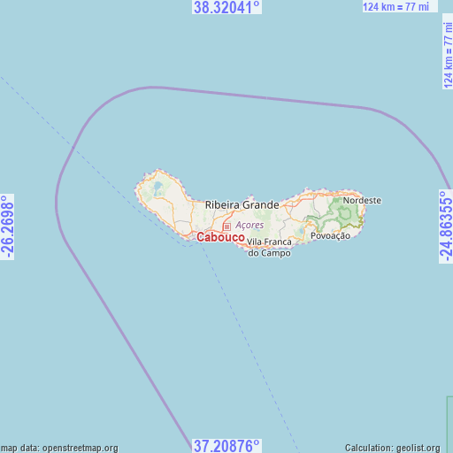
Cabouco GPS coordinates[2]
37° 46' 0.012" North, 25° 34' 0.012" West
| Map corner | latitude | longitude |
|---|---|---|
| Upper-left | 38.32041°, | -26.2698° |
| Center: | 37.76667°, | -25.56667° |
| Lower-right: | 37.20876°, | -24.86355° |
| Map W x H: | 123.6×123.6 km | = 76.8×76.8mi |
| max Lat: | 42.11337° ⇑86.8% North |
| Cabouco: | 37.76667° |
| min Lat: | ⇓13.2% South 32.6448° |
| min Long | Cabouco | max Long |
| -31.17847° | -25.56667° | -6.27308° |
| W 5.2%⇐ | ⇒94.8% E |
Elevation
Elevation of Cabouco is 184 m = 604 ft, and this is 7 m = 23 ft above average elevation for this country.
| Max E: |
1008 m = 3307 ft | 33.6% |
| Cabouco | 184 m 604 ft | |
| Avg. | 177 m = 581 ft | |
Min E: |
-128 m = -420 ft | 66.4% |
See also: Portugal elevation on elevation.city.
Geographical zone
Cabouco is located in North temperate zone (between Tropic of Cancer and the Arctic Circle). Distance of this Northern Tropic circle is 1593.3 km =990 mi to South.| Distance of | km | miles | from Cabouco |
|---|---|---|---|
| North Pole | 5807.8 | 3608.8 | to North |
| Arctic Circle | 3201.9 | 1989.6 | to North |
| Tropic Cancer | 1593.3 | 990 | to South |
| Equator | 4199.3 | 2609.3 | to South |


Nearby cities:
15 places around Cabouco: (largest is in red/bold)
• Arrifes
11.7 km =7.3 mi,  270°
270°
• Fajã de Baixo
7.6 km =4.7 mi,  255°
255°
• Fenais da Luz
9.3 km =5.8 mi,  314°
314°
• Lagoa
2.5 km =1.6 mi,  190°
190°
• Ponta Delgada
9.5 km =5.9 mi,  251°
251°
• Rabo de Peixe
5 km =3.1 mi,  343°
343°
• Relva
13.4 km =8.3 mi, 263°
• Ribeira Grande
7.3 km =4.5 mi,  32°
32°
• Ribeira Seca
6.3 km =3.9 mi, 27°
• Ribeira Seca
14 km =8.7 mi,  110°
110°
• Rosto de Cão
7.6 km =4.7 mi, 255°
• São Roque
6.7 km =4.2 mi, 258°
• São Vicente
10.4 km =6.5 mi,  303°
303°
• Vila Franca do Campo
13 km =8.1 mi,  115°
115°
• Água de Pau
7 km =4.3 mi,  136°
136°
Sources, notices
• [Note1] Compared only with cities in Portugal existing in our database
• [Src1] Map data: © OpenStreetMap contributors (CC-BY-SA)
• [Src2] Other city data from geonames.org with taken over terms of usage.
• [Src3] Geographical zone / Annual Mean Temperature by Robert A. Rohde @ Wikipedia
