Zvoriştea geodata
Zvoriştea (Suceava) is a seat of a second-order administrative division; located in Romania in Europe/Bucharest (GMT+3) time zone. With population of 6,275 people, there are 498 cities with bigger population in this country. Compared to other cities in Romania, 97.1% of cities are located further ↓South; 68.4% of cities are located further ←West and 63% of cities have lower elevation than Zvoriştea. Note1


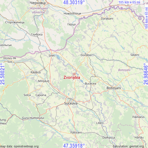
Zvoriştea GPS coordinates[2]
47° 49' 59.988" North, 26° 16' 59.988" East
| Map corner | latitude | longitude |
|---|---|---|
| Upper-left | 48.30319°, | 25.58021° |
| Center: | 47.83333°, | 26.28333° |
| Lower-right: | 47.35918°, | 26.98646° |
| Map W x H: | 105×105 km | = 65.2×65.2mi |
| max Lat: | 48.23793° ⇑2.9% North |
| Zvoriştea: | 47.83333° |
| min Lat: | ⇓97.1% South 43.65638° |
| min Long | Zvoriştea | max Long |
| 20.31667° | 26.28333° | 29.65403° |
| W 68.4%⇐ | ⇒31.6% E |
Elevation
Elevation of Zvoriştea is 279 m = 915 ft, and this is 24.1 m = 79 ft above average elevation for this country.
| Max E: |
1278 m = 4193 ft | 37% |
| Zvoriştea | 279 m 915 ft | |
| Avg. | 254.9 m = 836 ft | |
Min E: |
-2 m = -7 ft | 63% |
See also: Romania elevation on elevation.city.
Geographical zone
Zvoriştea is located in North temperate zone (between Tropic of Cancer and the Arctic Circle). Distance of this North polar circle is 2082.6 km =1294.1 mi to North.| Distance of | km | miles | from Zvoriştea |
|---|---|---|---|
| North Pole | 4688.5 | 2913.3 | to North |
| Arctic Circle | 2082.6 | 1294.1 | to North |
| Tropic Cancer | 2712.6 | 1685.5 | to South |
| Equator | 5318.6 | 3304.8 | to South |


Nearby cities:
15 places around Zvoriştea: (largest is in red/bold)
• Berești
6.8 km =4.2 mi,  145°
145°
• Bucovineni
4.2 km =2.6 mi,  63°
63°
• Buda
2.1 km =1.3 mi,  308°
308°
• Călugăreni
7.7 km =4.8 mi,  176°
176°
• Dealu
0.8 km =0.5 mi,  264°
264°
• Ionășeni
8.2 km =5.1 mi,  106°
106°
• Lunca
5.6 km =3.5 mi,  351°
351°
• Nicani
5.7 km =3.5 mi, 313°
• Poiana
4.2 km =2.6 mi,  187°
187°
• Slobozia
5.3 km =3.3 mi, 146°
• Stânca
1.6 km =1 mi,  215°
215°
• Talpa
8.4 km =5.2 mi,  335°
335°
• Vârfu Câmpului
3.8 km =2.4 mi,  68°
68°
• Zamostea
7.2 km =4.5 mi,  300°
300°
• Șerbănești
3.7 km =2.3 mi,  133°
133°
Sources, notices
• [Note1] Compared only with cities in Romania existing in our database
• [Src1] Map data: © OpenStreetMap contributors (CC-BY-SA)
• [Src2] Other city data from geonames.org with taken over terms of usage.
• [Src3] Geographical zone / Annual Mean Temperature by Robert A. Rohde @ Wikipedia
