Vârfu Câmpului geodata
Vârfu Câmpului (Botoşani) is a seat of a second-order administrative division; located in Romania in Europe/Bucharest (GMT+3) time zone. With population of 2,115 people, there are 2501 cities with bigger population in this country. Compared to other cities in Romania, 97.3% of cities are located further ↓South; 69.5% of cities are located further ←West and 65.4% of cities have lower elevation than Vârfu Câmpului. Note1


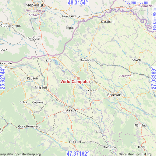
Vârfu Câmpului GPS coordinates[2]
47° 50' 44.376" North, 26° 19' 50.016" East
| Map corner | latitude | longitude |
|---|---|---|
| Upper-left | 48.3154°, | 25.62744° |
| Center: | 47.84566°, | 26.33056° |
| Lower-right: | 47.37162°, | 27.03369° |
| Map W x H: | 104.9×104.9 km | = 65.2×65.2mi |
| max Lat: | 48.23793° ⇑2.7% North |
| Vârfu Câmpului: | 47.84566° |
| min Lat: | ⇓97.3% South 43.65638° |
| min Long | Vârfu Câmpulu | max Long |
| 20.31667° | 26.33056° | 29.65403° |
| W 69.5%⇐ | ⇒30.5% E |
Elevation
Elevation of Vârfu Câmpului is 292 m = 958 ft, and this is 37.1 m = 122 ft above average elevation for this country.
| Max E: |
1278 m = 4193 ft | 34.6% |
| Vârfu Câmpului | 292 m 958 ft | |
| Avg. | 254.9 m = 836 ft | |
Min E: |
-2 m = -7 ft | 65.4% |
See also: Romania elevation on elevation.city.
Geographical zone
Vârfu Câmpului is located in North temperate zone (between Tropic of Cancer and the Arctic Circle). Distance of this North polar circle is 2081.2 km =1293.2 mi to North.| Distance of | km | miles | from Vârfu Câmpului |
|---|---|---|---|
| North Pole | 4687.1 | 2912.4 | to North |
| Arctic Circle | 2081.2 | 1293.2 | to North |
| Tropic Cancer | 2714 | 1686.4 | to South |
| Equator | 5319.9 | 3305.6 | to South |


Nearby cities:
15 places around Vârfu Câmpului: (largest is in red/bold)
• Berești
7 km =4.3 mi,  177°
177°
• Bucovineni
0.5 km =0.3 mi,  23°
23°
• Buda
5.2 km =3.2 mi,  269°
269°
• Dealu
4.5 km =2.8 mi,  251°
251°
• Ionășeni
5.7 km =3.5 mi,  129°
129°
• Lunca
6 km =3.7 mi,  313°
313°
• Nicani
8.1 km =5 mi,  288°
288°
• Poiana
6.8 km =4.2 mi,  216°
216°
• Poiana
7 km =4.3 mi,  90°
90°
• Saucenița
7.3 km =4.5 mi,  42°
42°
• Slobozia
5.8 km =3.6 mi,  186°
186°
• Stânca
5.2 km =3.2 mi,  238°
238°
• Văculeşti
7.7 km =4.8 mi,  56°
56°
• Zvoriştea
3.8 km =2.4 mi, 248°
• Șerbănești
4 km =2.5 mi, 192°
Sources, notices
• [Note1] Compared only with cities in Romania existing in our database
• [Src1] Map data: © OpenStreetMap contributors (CC-BY-SA)
• [Src2] Other city data from geonames.org with taken over terms of usage.
• [Src3] Geographical zone / Annual Mean Temperature by Robert A. Rohde @ Wikipedia
